6-8" of snow....but because of the cold air...that could easily be 10" or 12" in many spots.
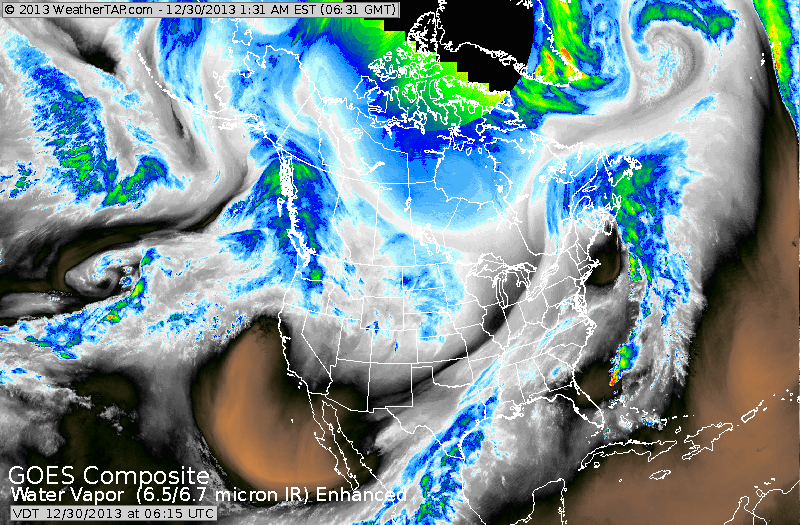
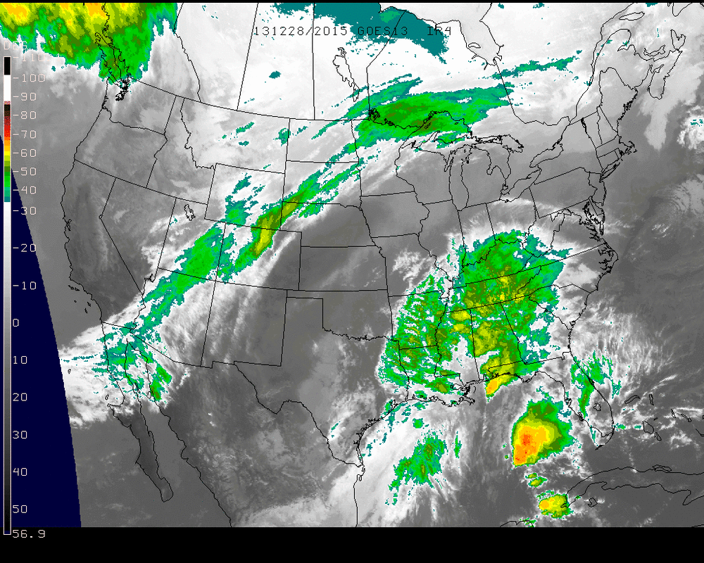
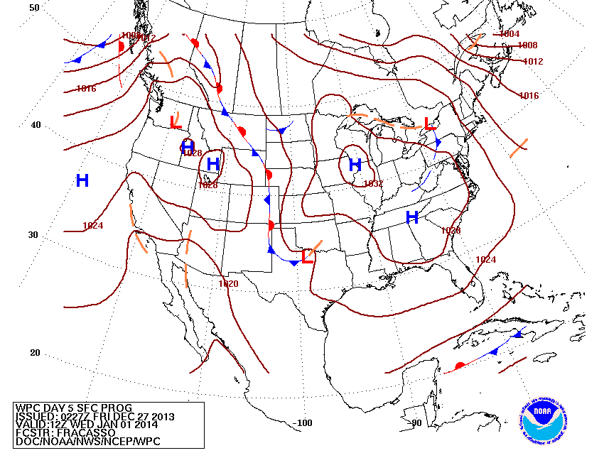
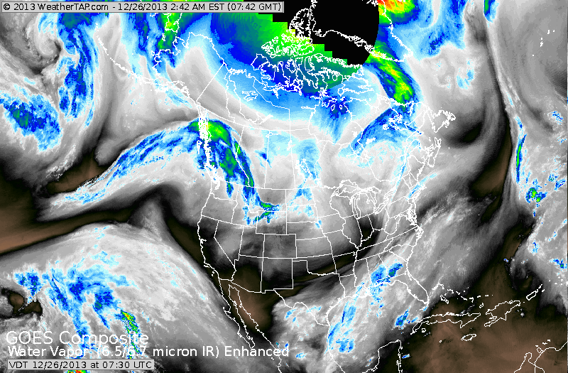
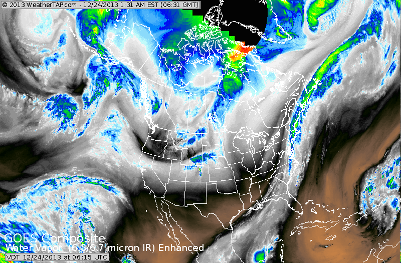
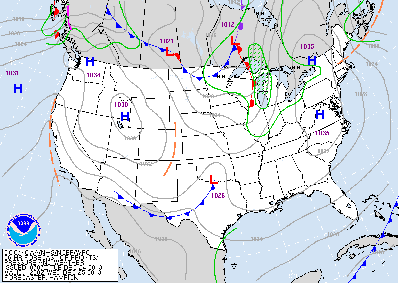
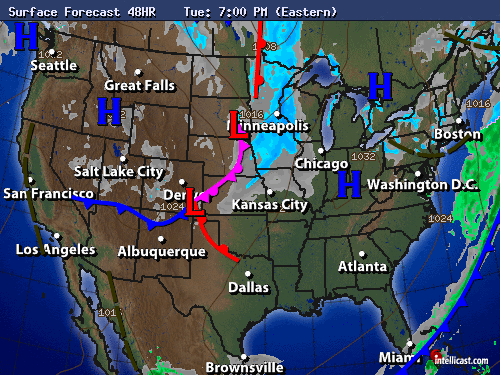
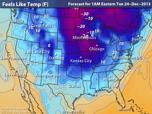
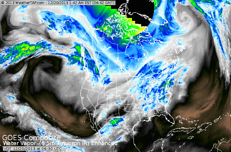
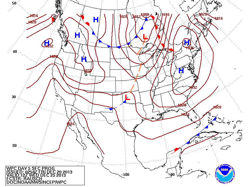
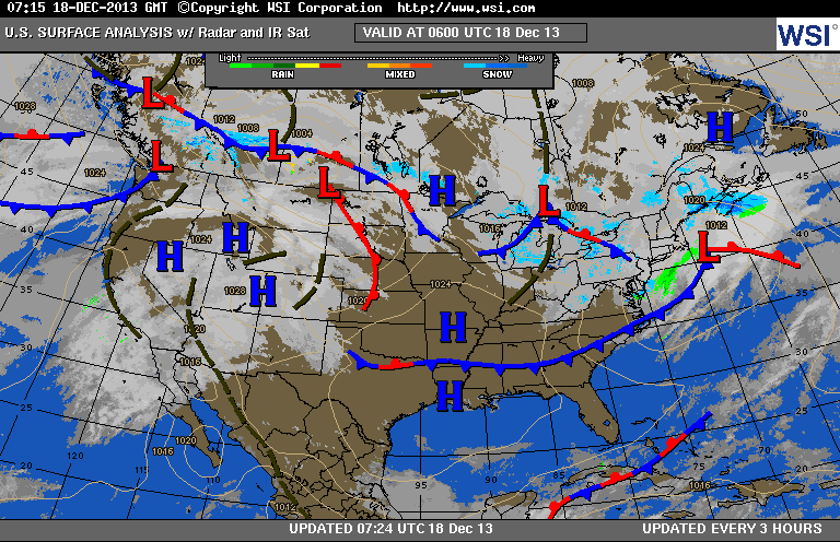
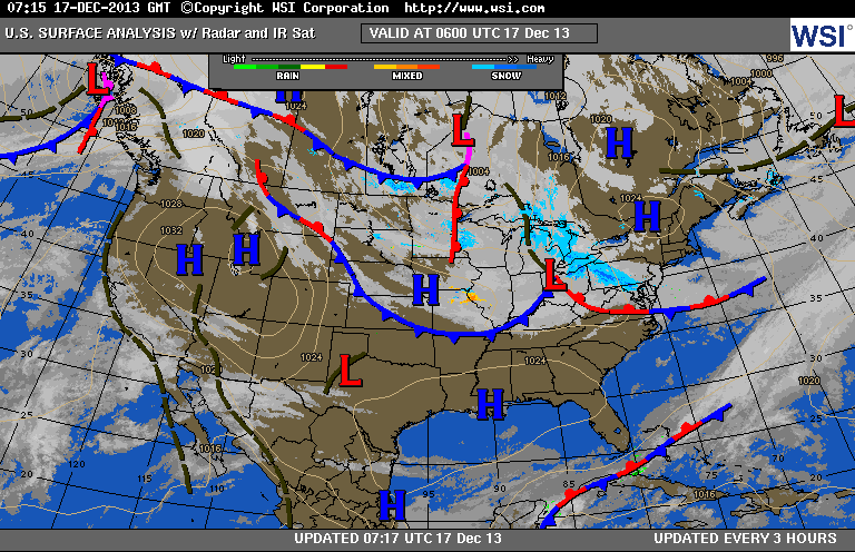
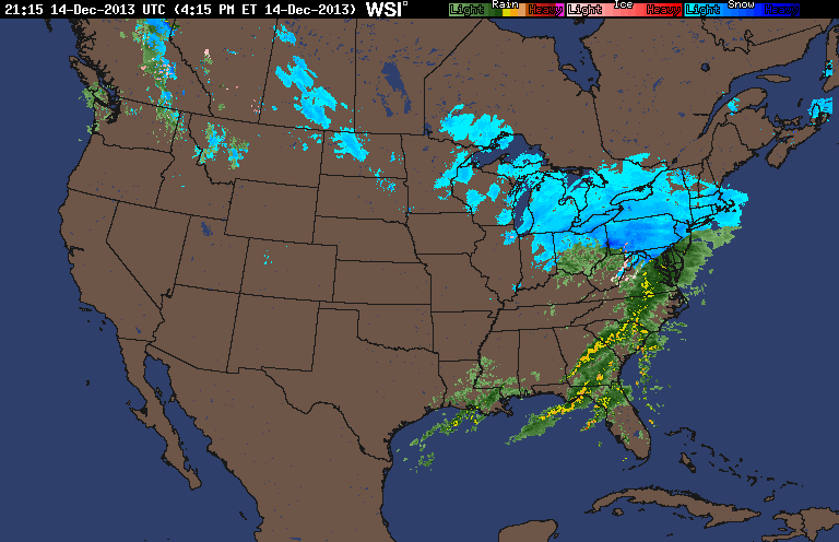
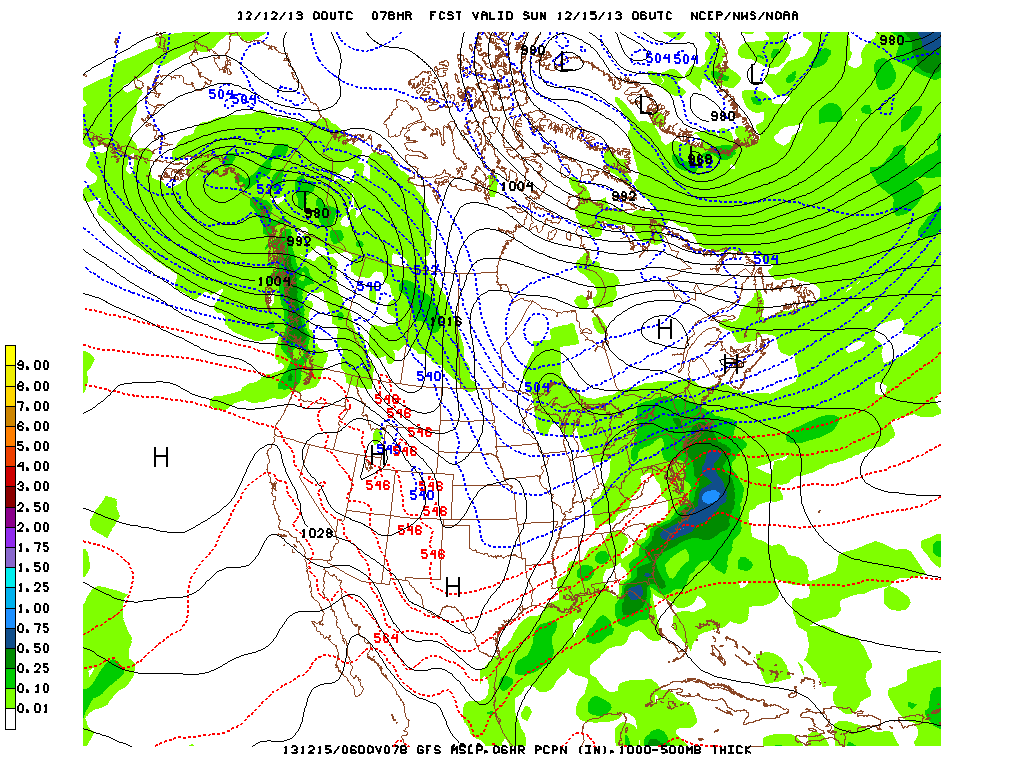
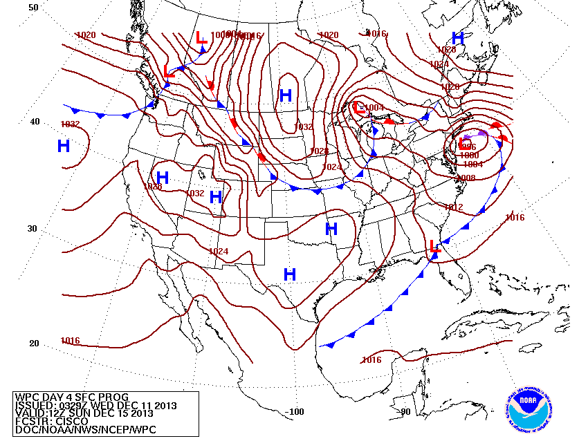
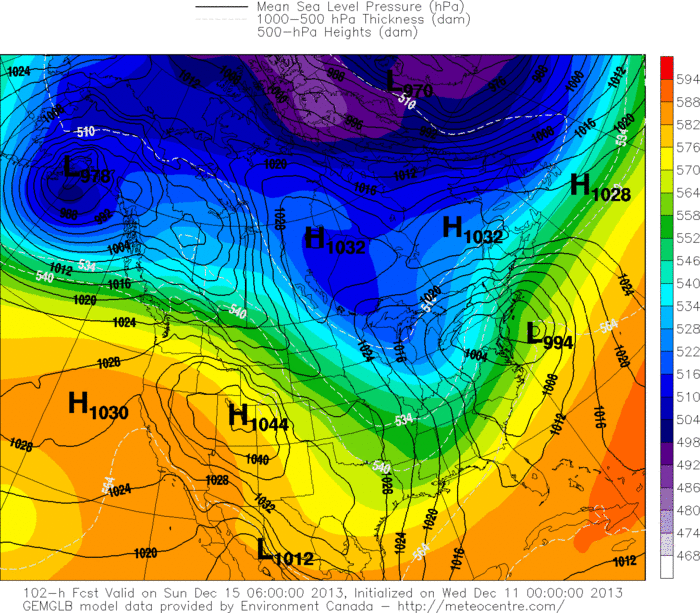
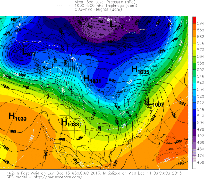
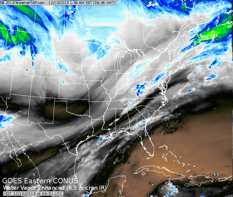
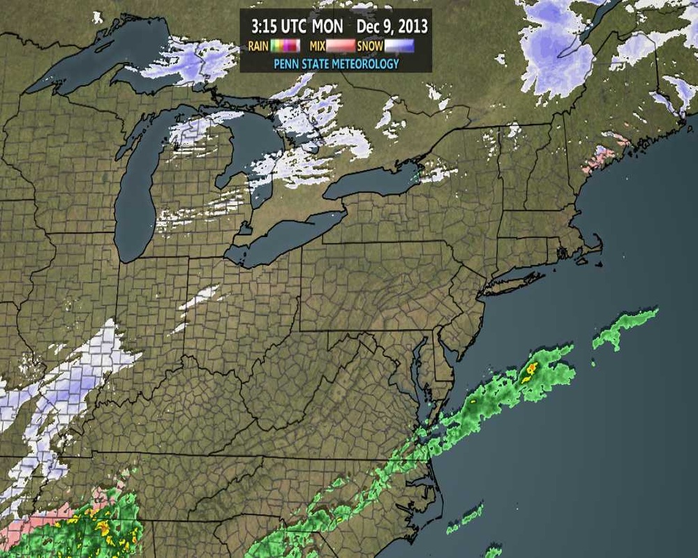
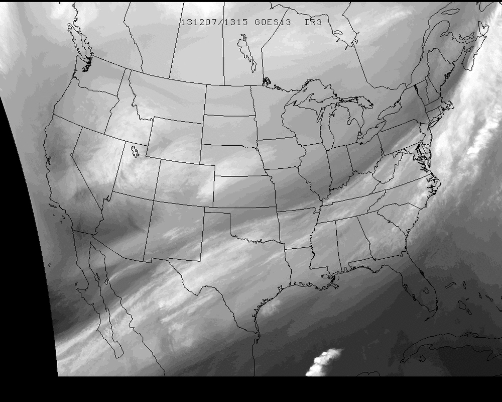
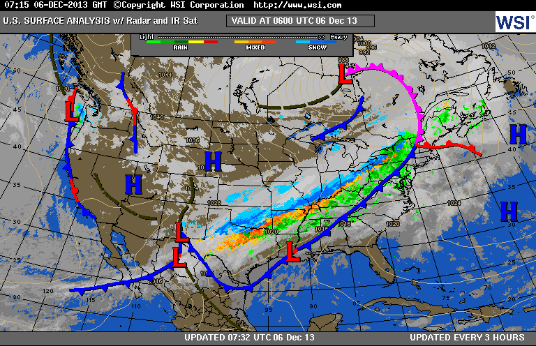
An arctic low scooting down the Rockies will soon or later team up with a low from the Gulf States and produce snow and arctic winds from Ohio Valley east to Mid Atlantic and Northeast. Satellite picture shows the 2 streams of moisture and jet streams and where they combine will be the worst weather...which seems to be the Northeast on Friday. 
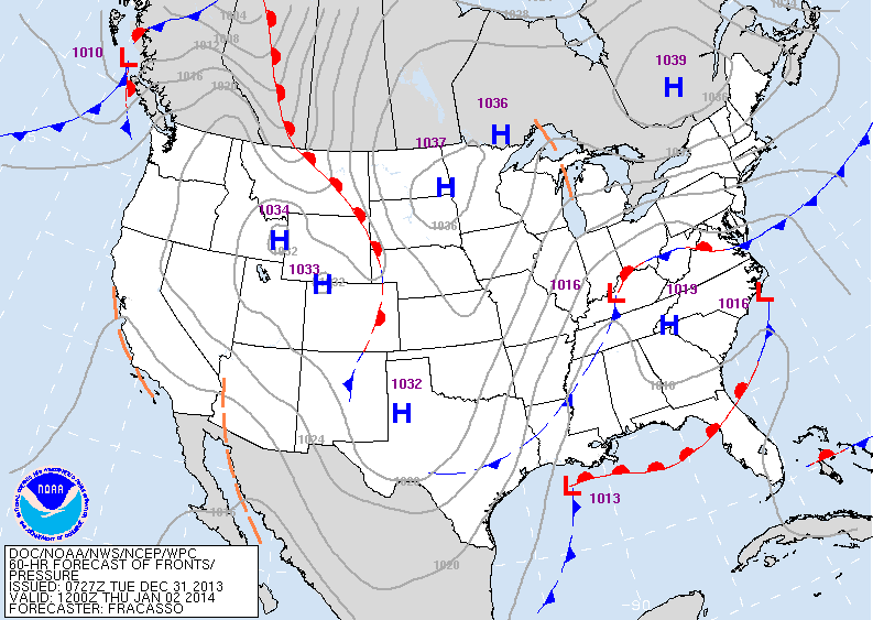
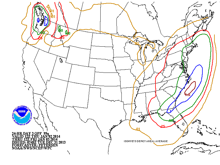
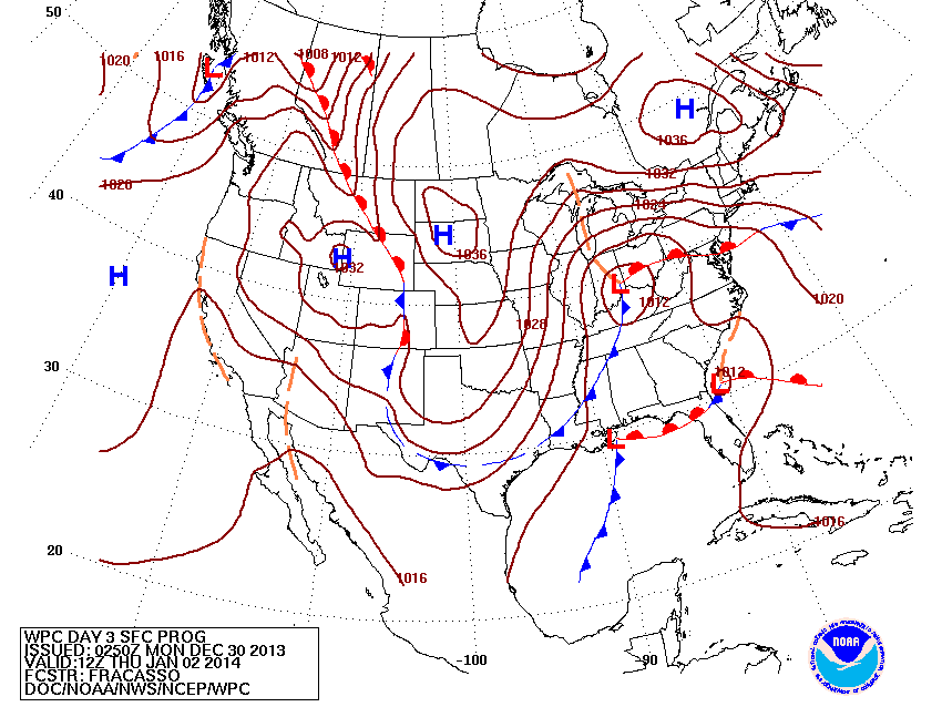
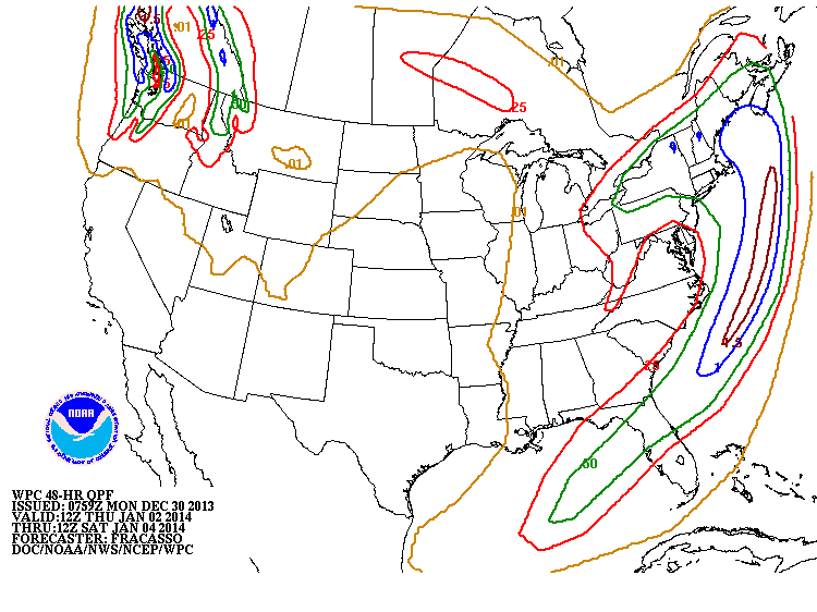
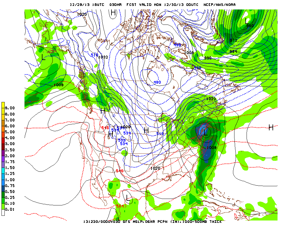
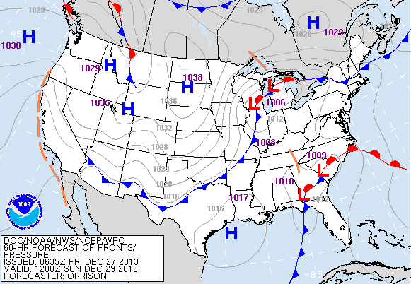
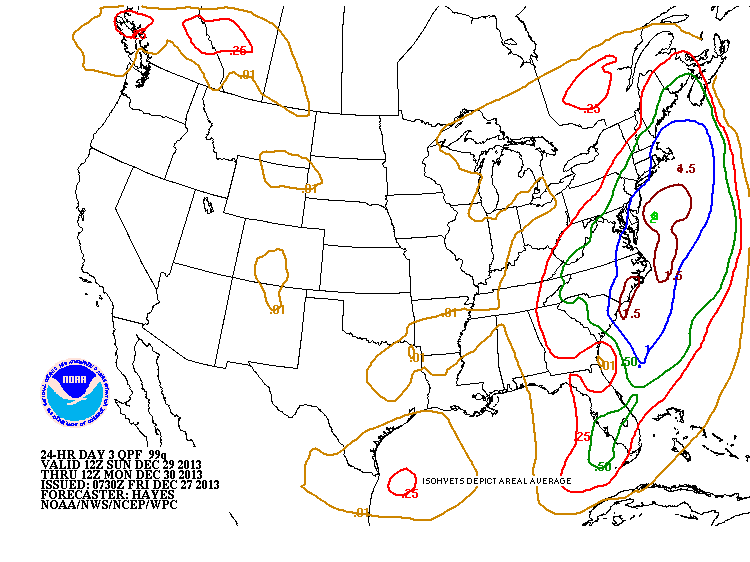
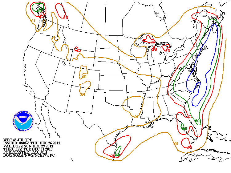
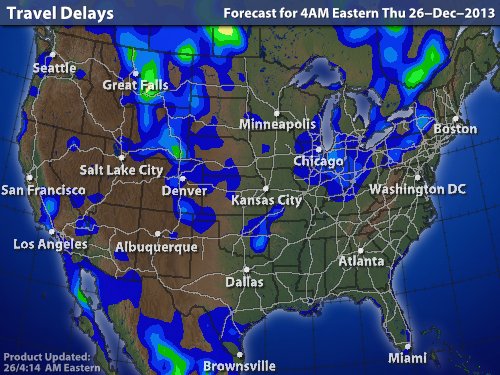
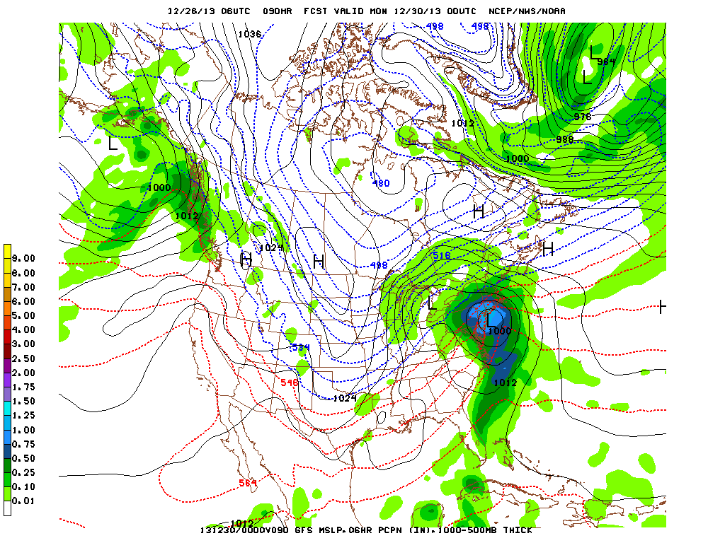
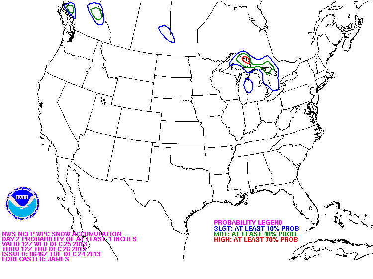
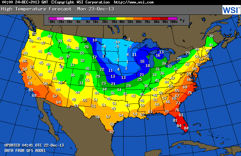
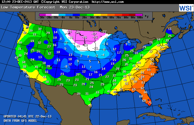
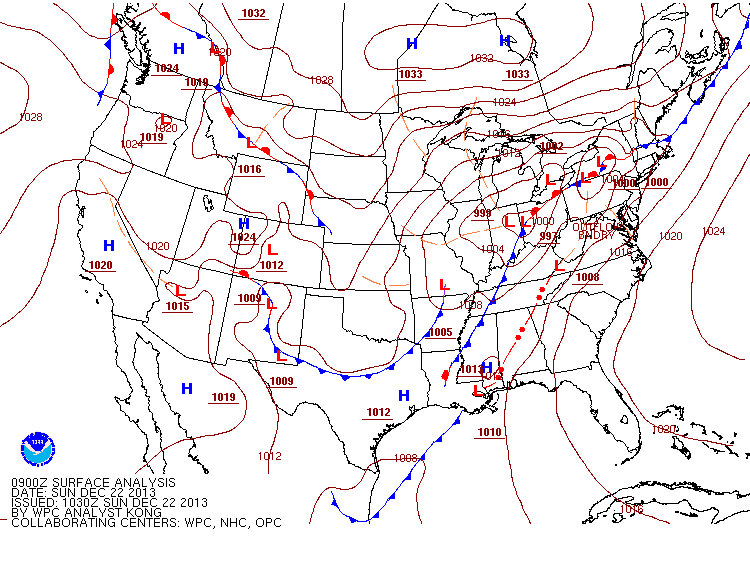
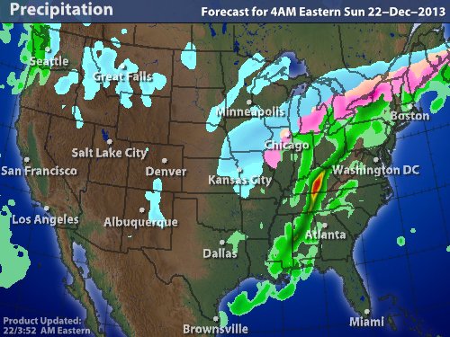
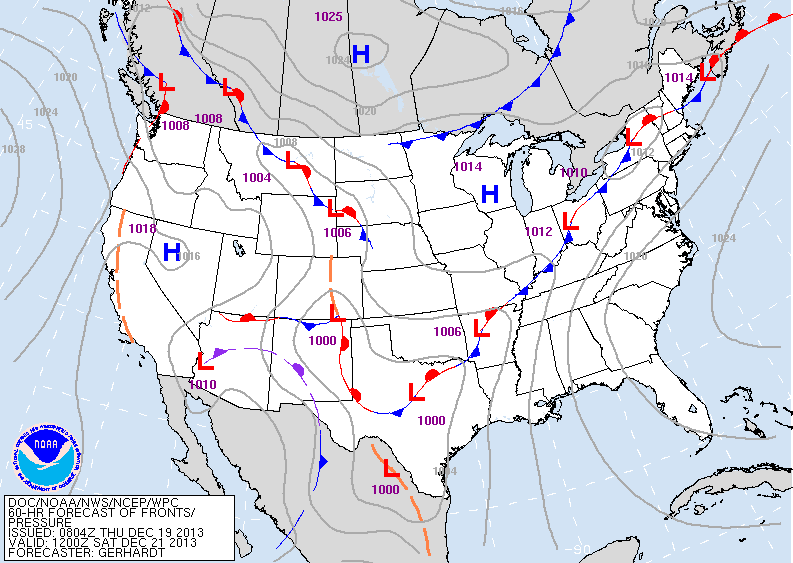
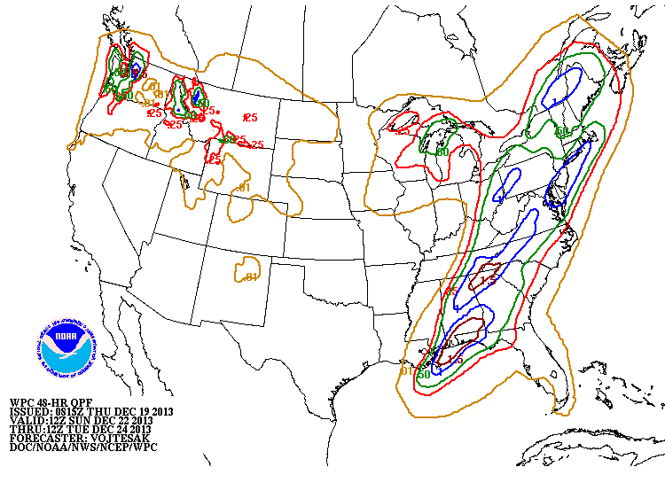
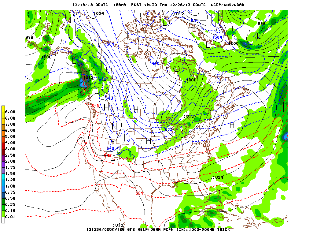
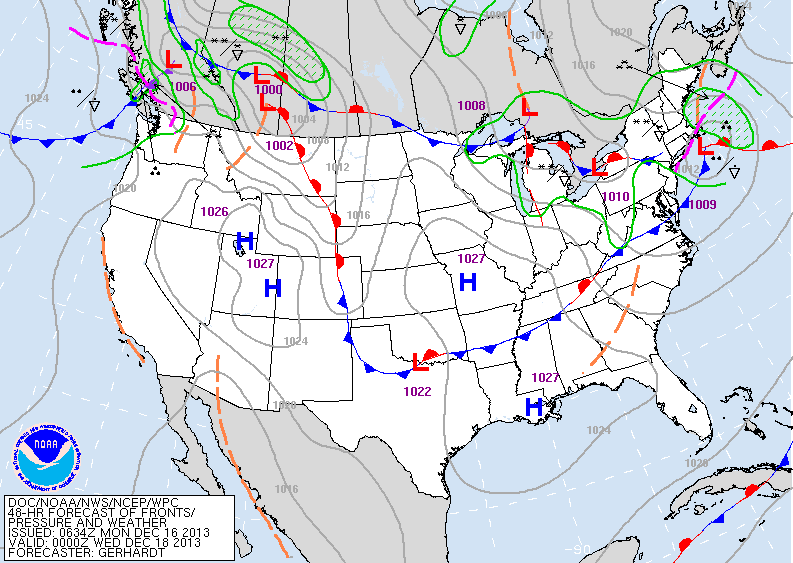
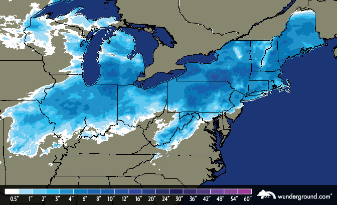
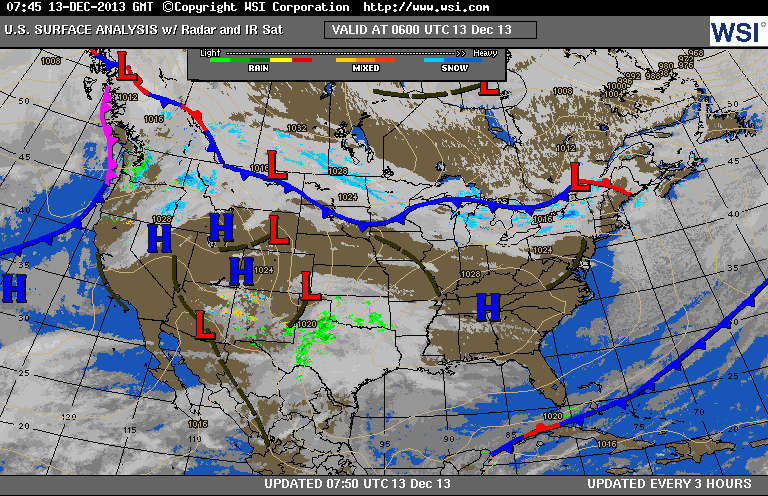
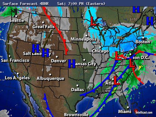
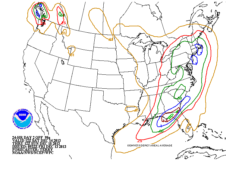
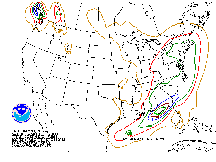
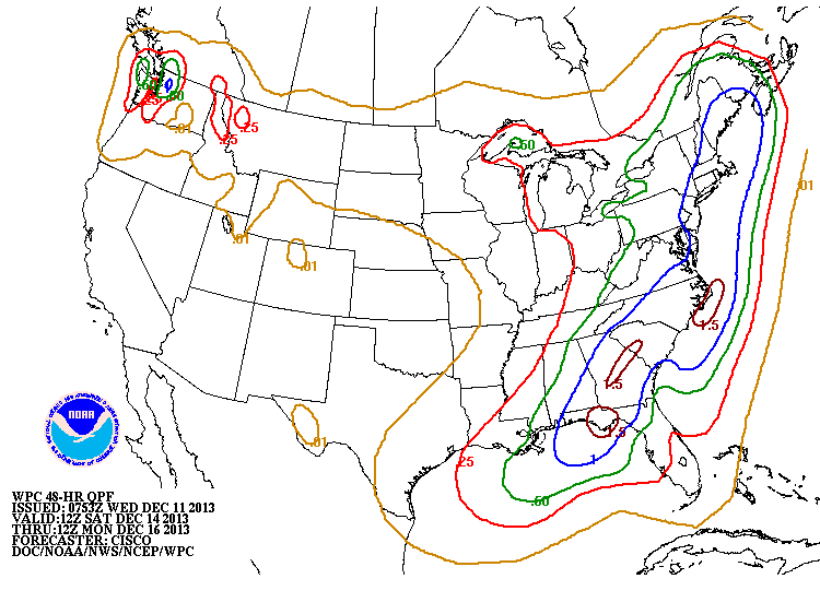
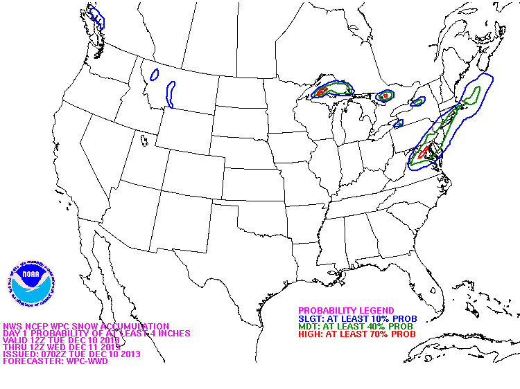
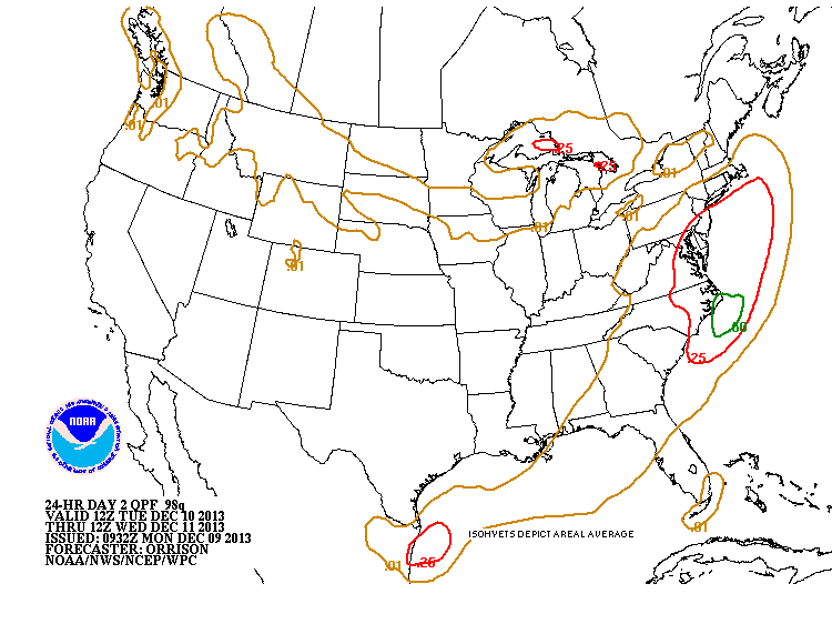
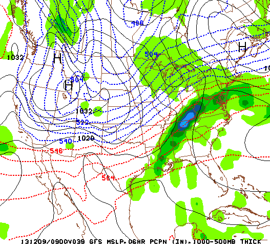
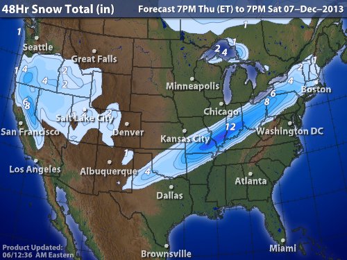
Below...weather map for Thursday....depicting the storms we spoke about above. Below that...amounts of liquid that could fall with this system. Generally... 3/4" liquid for The Northeast ....which would mean 6-8" of snow....but because of the cold air...that could easily be 10" or 12" in many spots. Would like to take this opportunity to thank you for visiting our site and making it so successful. Our wishes for a Happy...Healthy ...Safe New Year's.
0 Comments
Veil of clouds from Buffalo - NY to Texas is a cold front moving east. Light blue is Dakotas...a clipper low..which will bring colder air east by New Year's. In The Youkon...a disturbance that will head southeast and bring mostly snow to NE Thursday...followed by bitter cold arctic air. Latest surface map showing cold front headed for East Coast...and lows out west to follow. Below - map showing what we expect Thursday to look like with a winter storm affecting The Eastern Third of The Nation. This map - valid for Thursday shows one low in Ohio Valley and another forming off Southeast coast. The 2 will combine to become a big storm off New England Friday...when powerful arctic winds will follow dropping temps into the single numbers as far as NYC & PHL...and below zero from NY State across New England. This map shows how much moisture could fall with the eastern storm.
Green line represents 4" or more from NYC north...while anywhere between the green and blue lines could get 10-12". More on this tomorrow. Later. First off if you're south of central CT, there won't be any snow for you to shovel! The bad news for those north of that line though won't be the snow as much as it will be the wet ground freezing into ice. So for those of you seeing rain during the day and snow during the night, just be careful of black ice on the roads and for any ice hiding under the snow. The surface map may not look like much, but the radar tells another story. The north will have frigid temperatures with highs in some areas only at -10°F and the wind chills will be even worse with -40°F widespread but -50°F locally. Lows will be in 30° to 40° below zero as well.
New Years at midnight for many areas will be quite cold as well, and Times Square will be around the mid 20's so not too bad (last year was around the same within a few degrees). After today's the wet day we'll be in the clear until Thursday when the temperatures will drop even more and many areas will see snow showers. Make sure you have your umbrellas at the ready for today though. -Mike Merin The trends in the models are bringing the storm system through the northeast at a faster pace, and also centered further north, thus resulting in a warmer situation, and much less snow likely throughout sections of New York and New England. The Infrared imagery from this Saturday afternoon shows the storm in the southeast with plenty of moisture and it will retain all of it and more as it traverses up the eastern seaboard Sunday. The GFS models form midday today bring the Low right across Long Island by 7 pm ET. The center may be travel bit slightly further north but the overall path is northeast, into the night. Even portions of Massachusetts and southern New Hampshire & southern Maine will be susceptible to a decent amount of rainfall to wash away any threats of a major winter storm. In the more mountainous regions further north and the mainland of Maine is where the threat for major snow accumulations will be.
After this passes, the Arctic High that will bring many negative temperatures to the upper Midwest on Sunday & Monday will bring 10's and 20's to parts of the Northeast to finish off 2013. - JL Current map shows calm conditions but a storm moving out of the Gulf States and up the East Coast Sunday will bring rain there...with a heavy wet snow and sleet combo for Northern New England. Colder weather will engulf the Plains and head east so by New Year's Day almost the entire Eastern 2/3 of The Nation will be under arctic air including Florida. This map (above) is valid for Sunday. Southern storm to bring rain to the East...storm near Chicago will head east and allow arctic air to push east. Below...chart showing rainfall amounts for the East... 1.00" of rain along the coastal areas. If that would have been snow... a heavy 10-12" would have fallen. This map is valid for New Year's Day. It shows high pressure dominating...but that high is cold...and although dry...temps are going to average WELL.....below the average....so we definitely get the cold shoulder from Ms. Nature for the New Year. Have a nice and safe weekend.
Hope everyone had a nice Christmas. Satellite pix shows a small disturbance moving across the Northeast today. Notice the moisture in the Gulf off Texas. Notice the next front moving down thru The Plains. The 2 will combine to bring a storm up the East Coast Sunday with rain or major cities. Snow and ice possible for interior New England. Progressively colder weather to end the year. The chart below shows the amount of rain expected Sunday....heaviest along East Coast with 1" expected. Map below is current weather map....with only light precip noted. As a result travel delays today are expected to be light....(2nd map). Map below is The GFS Model valid for this coming Sunday evening. You will notice the Low along the coast with heavy rain....heavy snow
for places like Vermont/ New Hampshire. Following that storm...a cold pattern becomes established for end of year and early next year....and with that will come bouts of snow from west to east so be prepared. Later. The map above shows a cold front off the coast to Florida...where showers will be possible for rest of week...especially southern areas. Cold front stretching from Ohio to Texas may bring some flurries to Northeast today. Low in Montana will bring a few inches of snow to No. Plains and upper Midwest today. Below...satellite picture shows the blue over Rockies...that's the "White Christmas" snow for Northern Plains and Gt. Lakes. Below...weather map for Christmas Day...again ...showing best chance of snow falling over The Great Lakes. Below that...a map depicting the best probabilities of snow....(blue). On behalf of all the staff at Metro Weather....here's wishing everyone a very Merry and Safe Christmas.
Front over The East will result in wet weather today...with a gradual turn to colder weather. Tuesday into Christmas Day will be colder but fair and dry. Some snowshowers possible late week from Northern Plains to New England...and showers of So. Florida...otherwise quiet. Locally heavy rain today for East Coast....otherwise locally heavy snow Pacific Northwest into Norther Rockies....with much of the Nation..dry. Above map is valid for Christmas Eve. SNowshowers in lee of Great Lakes....a general light snow upper Midwest...and local snow in Rockies. About 80% of our Nation will be quiet. Quiet is good. Later.
Quite the disparity in the US in the upcoming week. As you work your way out from Minnesota and the Dakotas, it'll start off incredibly cold and then slowly look like Summer temps as you go Southeast and the fall elsewhere. It's hard to believe that the shortest day of the year was yesterday with these temps. Much of the nation will see record highs today, some beating it by as much as 5-10° in areas like NC and Delmarva. It's areas though like the northern plains that would make most people want to stay inside as lows will drop well into the negative 20's with wind chills in some spots at 40° below zero, ouch. Tomorrow's lows will be even lower for those states, with negative 30's for temps and as low as -50° wind chills. As far as the current precip though, the strong Low is still sitting between the Great Lakes and the Atlantic with plenty of moisture strewn about it. From Chicago through the US/Canada border will see a wintry mix with a widespread area within it seeing dangerous freezing rain and even ice storms. As you follow the cold front itself you'll see the heaviest bands of rain bringing areas of flash flooding, with even thunderstorms in Kentucky that will make its way through the central states. Yes that's right, concentrated strong and severe thunderstorms in December. It's supposed to be Winter right? I'm not complaining though, after all you don't have to shovel rain.
-Mike Merin The stories for this weekend are the record high temperatures hitting the Eastern US, but also the storm that is accompanying all that warm air. The national IR map shows the center of the low pressure system in the general Texas area and the extensive distance the associated fronts with it covers (all the way through to Maine and further northeast. The flow can be seen also by looking at the 500 mb plot by observing the wind barbs, dipping down west of the Rockie Mountains and flowing back up through Texas & the Gulf of Mexico. The red numbers next to each plot represents 500mb heights or thicknesses in decameters (dm). The height values in the southeast are reaching 5700 meters (decameters x 10) and higher, values you do not tend to see on the first day of winter but much earlier in the Fall, and we can associate these values with warmer air temperatures. These are producing record highs today in many areas and will continue to do into Sunday.
This system is a very complex one and will take time to move out, producing severe weather in the southeast, but tame rain showers in the northeast... By late Monday and into Tuesday morning, the cold front will have passed on and the frigid air will return once again just in time for Christmas Eve and subsequently Christmas Day on Wednesday. While some light snow activity could be seen Tuesday off of the Great Lakes, conditions for Christmas for right now in the Northeast appear to be dry, cold and not quite a "White Christmas". - JL Animated satellite loop shows warm moist air surging across Gt.Lks and Ohio Valley...so cloudy..milder weather with showers beginning to head to East Coast. Notice the blue/green area in Texas. That is the next storm that will head northeast and not only be a big precip. producer....but result in severe weather for lower Mississippi Valley Saturday when severe thunderstorms and tornadoes are possible. On the other side of the storm...Central Plains into western Great Lakes will see ice then snow...4" + Rains amounts expected Sunday into Monday. 3" from New Orleans to Atlanta. Expected weather map for Christmas Day. Fair..dry cold..East...some snowshowers upper Midwest into Great Lakes....otherwise most of the country quiet. GFS Model for New Year's Eve. Clearing wants to bring snow from Mid Atlantic to Northeast.....not a biggie...but enough to make travel unattractive. Snowshowers from Rockies to upper Great Lakes. (green indicates moisture/ precip). We'll follow this...but I do think that the end of year or start of the new will present weather problem for East Coast.
Have a nice weekend...happy shopping and partying. BTW, most watched holiday movie on tv - It's A Wonderful Life. Satellite picture shows a speck of blue in New York State...that's lake effect. Aside from that....the mass of blue and green out west is the next front which will press only slowly east allowing a mild up. By Sunday..temps could approach 70 away from the shore along the East Coast...with showers...and snowmelt ! Colder weather thereafter. This map valid for Saturday. You can see the front wiggling from NYS to Texas. East of front...mild..and sometimes wet....in back of the front colder with some mixed precip. Below....generous amounts of rain with and ahead of front thru weekend. Places that have snowpack..will not only have fog to deal with but melting and flooding. Lastly...this is the GFS for Wednesday...Christmas Day. IT shows a front through the Gt Lakes with some snow...so from Wisconsin to Michigan and even Chicago...some snowshowers will fall making it a true White Christmas there. Colorado will have some snow...and so. Florida will have some rain. Trivia Christmas question: What is the most watched Christmas movie ? Answer tomorow.
A little snow around Great Lakes....not including lake effect...otherwise a quiet time. Clouds are plenty...but at least stormy weather waits until the weekend. Amounts of precip. over the weekend. Up top 3" of rain expected in The Ohio Valley......some ice and snow upper Midwest. The entire pattern will shift east Sunday into Monday.....but some places along the East Coast...as far north as New England will get into the 60s...so flooding a problem. Our snowfall map shows extensive snowcover...which will help keep cold air - cold.....and could also play a role in types of precip. Anyone in deep blue and pink....almost guaranteed a white Christmas. Later.
Weather Map below shows clipper low moving toward New England coast...giving the Northeast a 2-4" snowfall today into tonight. Elsewhere the very cold weather in the Northern Plains will hold...while it gets milder elsewhere. That milder weather works to the East coast this weekend with some rain. Satellite picture shows that clipper low near The Gt.Lakes....look closely. Next color enhancement in the Northwest will affect the Nation late week into the weekend with more rain than snow. Below...maps show expected highs across N.A. - this pattern holds for another day or two. Following map...shows reported cases of the flu. As usual...it took a big jump since November with people moving about more so. Stay warm..safe...later.
You can see the jet stream diving down the Rockies and turning up toward the East Coast. A cliiper low in upper Midwest will be off New England late Tuesday....bring a few more inches of snow to The Northeast. Unsettled weather for the Southwest. Later in the week it will get milder from west to east...but another cold front will cross Northern-tier by end of next weekend. Above...for late Tuesday. Clipper low near Buffalo...with second low off Cape Cod. Rest of the nation...high and dry. The East will see 50 or so
by week's end......keep in mind this is December...doesn't last all that long. Winter officially arrives Saturday....12:11pm eastern time. Later. For two days we've seen a winter storm hurl itself across the nation, and last night the NY metro area said hello to it. Though NY escaped with only a few inches of rain and minimal ice before heavy rain helped out, starting from West Chester and going north, into central PA, even parts of the region closer to NYC such as Northern NJ was a different story as you can see from the 2-day snowfall map below. This is only part of the story though as many areas experienced freezing rain for numerous hours with the temperature inversion. Places in SE PA saw up to .3" of ice accumulations ON TOP of the snowfall, while parts of southern central MA and northern CT saw up to an astonishing .4" And even for those who didn't receive any freezing rain, last night the snow partially melted during the night as temps rose as high as 34°F before refreezing once again as the temperatures suddenly dropped below 32°F. This caused nightmares on the roads as black ice formed in many plowed areas, and even worse in unplowed areas (as I can see out of my window now). There's still more snow in the forecast for today, but it's all north of Boston with Maine still getting hammered:
Now this is different than sleet which is only partial melting of the snow and results in slushier (temps are usually slightly above 32°F). You can see in the graphic below how each of these look. So with this storm over and done with for the NY metro area, the next low pressure system moving through will be on Tuesday. For NY it'll be rain, but as you go North there's another chance of snow in the morning/night with rain during the afternoon to break it up, but North still will be all snow.
Careful on the roads tonight as temperatures will dip well below freezing again and all the snow that melts today may become black ice. Keep an eye out and be safe. -Mike Merin The amount of moisture that this system houses along with its size are both quite remarkable. The snow has been moderate to heavy for much of Pennsylvania, and scattered in both frequency and intensity through New York, and southern New England. The rain-snow line will start to shift north slowly though as the low pressure system moves through the Mid-Atlantic states and just south of Long Island, and then northeast past Boston into tomorrow. The forecasted track of the system has not varied much in the past couple of days and continues to stay rather true to what we've been expecting. Freezing rain will be more of a concern inland (such as the Bronx, central Connecticut, and northeast New Jersey, as opposed to directly on the coast. This will cause issues to both road conditions and tree limbs and power lines.
Expected snowfall totals in the NY metropolitan area are as follows... Upwards of 6" in the NYC Metro area and much of Long Island (though lesser amounts along the east end of Long Island), Just north & west of New York City, 4"-8" with higher amounts towards northern Orange and Putnam counties and into northern Connecticut, southern Massachusetts, and Rhode Island. Up to a foot or more is possible in much of Pennsylvania, and into New Hampshire & Maine. Conditions turn try for most areas late Sunday and could see a bit of sunshine as well, especially throughout Monday, both quite windy days. ***It is highly recommended that you do not travel this evening unless absolutely necessary and be extremely cautious if you must as weather like this can prove to be very hazardous to the roadways.*** - JL You can see our California low over The 4 Corners Area....shoving moisture ahead of it. The Northern Jet is also evident across The Rockies. The 2 will phase but I don't think it will be as quickly as models suggest...therefore...precip. may not be as heavy...nor will things get as warm. There is still concern that the banked up cold air will lead one to a path of error....so that normal parameters that would suggest snow to rain...may not verify. There are lots of things about this situation that just don't sit right with me this a.m. Hopefully things will become clearer late today. Two maps above: first - current surface map...showing our storm moving thru Southern Plains. Second...what map will look like by early Saturday evening.....a mess ! 2"-4" of snow from NY Metro changing to sleet then rain..... 4"-8" interior NJ - Pa - NYS - New England...with a foot or more for NH & Maine. 4"-8" also possible across Ohio Valley. Above map shows amount of liquid to fall with this system. The 1" AMOUNTS (BLUE) mainly due to rain. As with all storms..things will change and so will our postings...so keep with us and be safe.
Even the satellite hasn't changed ! Can you see the small white circle over Southern California ? That's the instigator for the next storm. It doesn't appear that there will be a merger of the 2 jets in time to bring a large storm to The East....but enough to mess things up Saturday and Saturday night. Snow for the Eastern third of the Nation..with the heaviest from Indiana-Ohio..Pa...NY...and New England. These places will get 4+ with 6-8" from Hudson Valley in NY to New Hampshire. Above chart shows amount of liquid expected with the storm. Problem here....is that places that are real cold will have a better than 10 to 1 ratio. i.e. Albany NY expecting .50" liquid...normally 5" of snow but because it will be near 20 there...they could get 8". This is the GFS model for Saturday night. Storm is off mid Atlantic and rain/snow line is just south of Long Island, NY. Elsewhere across the Nation...cold...slowly easing but storm free. Later.
Cold air covers much of the Nation...and just how intense it is by this weekend will determine who gets the big snows. Two jet streams..one you can see swirling away off California....the other firing down the Rockies. These 2 will phase and a storm heads into Ohio Valley Saturday and then transfers off the coast as a nor'easter. To add wood to the fire...the northern jet will jump in and help to explode the storm off New England...who will likely get the biggest punch. This map shows the exploding storm south of Long Island Sunday...and the arctic low ready to dive in. These systems do not always behave as you would want...and often can bring as much ice...rain...as snow. Where that line sets up is hard to call right now...but if you are at least 75 miles aways from the shore..you could almost bet on more snow and ice than rain. This map shows how much liquid could fall this weekend. General...I mean general...rule....10" of snow for every 1" of liquid....you do the math. Above....Canadian model...then GFS Model. It's 5 days in advance of a storm and they are amazingly in same ball park. More on this tomorrow. Later.
You can see in our water vapor satellite...the jet pushing south...and the streak moving northeast from The Virginias to New York. That color enhancement will result in 1 to 4" of snow from Washington Dc to near Hartford, Ct. today...and quickly. Cold arctic air will follow for the rest of the week...with nothing but lake effect snows. This radar should be animated...in any event that snow in the Ohio
Valley is already moving in along the mid At. coast. Below...you will see the area most likely to receive 4" or more of snow. Blue represents the slightest chance....then each color within...shows an increasing chance. Today's unsettled weather in The East will ease but a new system will bring a swath of snow to Mid Atlantic and Southern New England Tuesday. Washington DC....PHily...NYC.....can all see 2-3" of snow Tuesday before cold air returns and stays most of the work/school week. This water vapor shows the band of moisture affecting the East...but as the next jet streak comes in from the Plains...a low will eject from the
Southeast and bring that snow mentioned above. Arctic cold continues in Rockies and Plains. Below you will see weather map for Tuesday... as well as amounts of liquid .....which converted to snow...would equal 1"-3". Stay warm and safe. Later Saturday has been a rather quiet day across the country. The big story for this Saturday has been the cold air across the central US that would be abnormal for the middle of winter. Temperatures as south as Texas are in the 10's while many areas in states along the Canadian border did not even crack -10 F today. Today we'll take a look at the Water Vapor to look at where all the moisture in the atmosphere is situated. A defining pattern of flow can be seen here from southwest to northeast. This pattern will continue as Low pressure will surge along the Gulf coast and up the eastern seaboard to finish off the weekend. By early Monday, there will be 2 centers of low pressure, one in the Great Lakes region, the other just off the Mid-Atlantic coast. The secondary low will produce the bulk of the moisture that will range from snow showers late Sunday, to a mix with sleet & freezing rain in many areas of the mid-atlantic states overnight into Monday. Along the interior of this region, more snow is expected with colder air but accumulations are still expected to be rather light, an inch at most for many areas... The main concern will not be snow accumulation but rather the amount of mixed precipitation that falls as sleet and freezing rain cause even more problems. Closer to the coast, rainfall is expected most of Monday and will erase the aftermath from the Sunday evening event.
Much more will be specifically known tomorrow morning in terms of how spread out the mixed precipitation will be so check back for Mike Merin's discussion tomorrow. - JL Arctic cold front moving to East Coast....clearly defined on satellite picture. A new storm forming on bottom of cold front in Gulf on Sunday will bring heavy snow to Ohio and Tenn Valleys and a wintry mix to Mid Atlantic-Northeast from late Sunday into Monday. Weather map above...shows rain (green) changing to ice (orange)...to snow (blue) as temperatures drop rather quickly....so be ready East Coast. Below...expected snowfall Sunday. Changing weather...holiday travel = spreading germs. Below..latest map reporting cases of flu. In summary...rain changes to some sleet and snow before ending East Coast Saturday morning. New storm brings heavy snow Sunday into Monday for Ohio/Tenn Valleys and wintry mix for Mid.Atlantic & Northeast. Have a safe nice weekend.
Water vapor satellite shows strong jet stream moving down west coast and heading into Great Lakes. The blue/green represents moisture and the cold front which will cool East Coast this weekend. A storm in the southern jet will bring a wintry mix late Sunday into Monday for the East....and since it will follow on the heels of the cold front..the layer of cold air will be shallow...so any severe icing or heavy snow will be limited and not that widespread except across interior New England. Above maps shows expected rainfall with cold front Friday into Saturday. This upper air map is for 10 days out...and this zonal (west to east) flow would indicate more seasonable weather.....so not to worry.....you will still have good weather to shop by. Stay safe...later.
|
We'll have daily weather discussions, talking about major systems on the horizon along with anything noteworthy that pops up on our radar.
Pat Pagano,
|