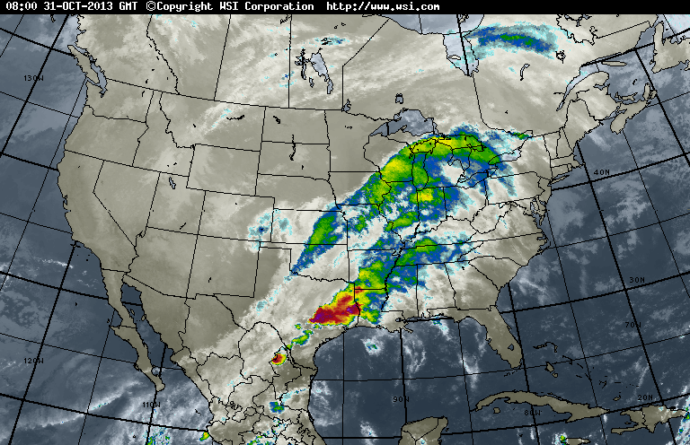
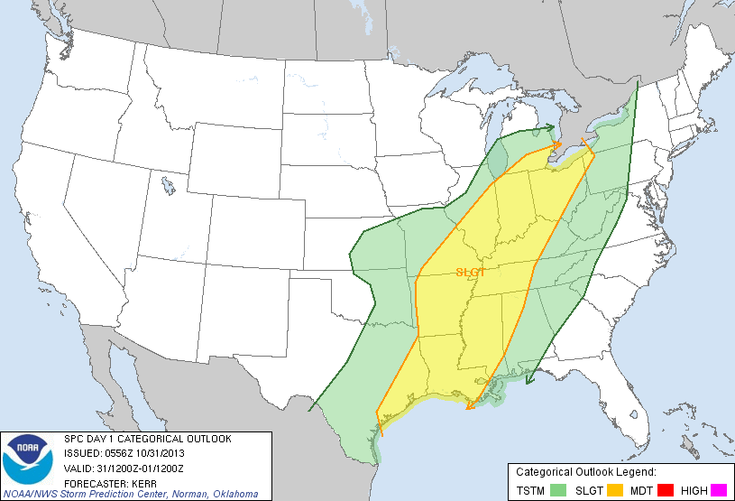
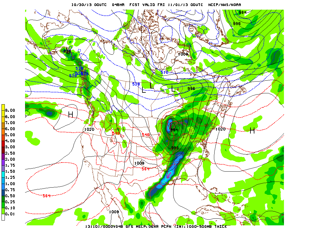
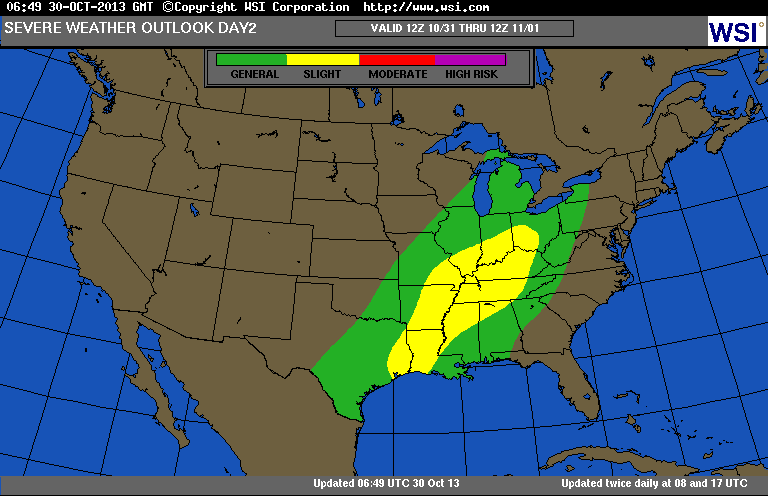
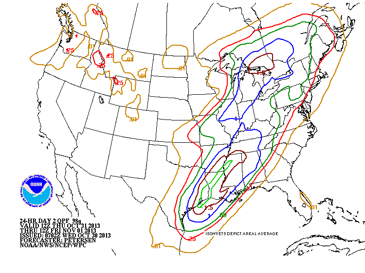
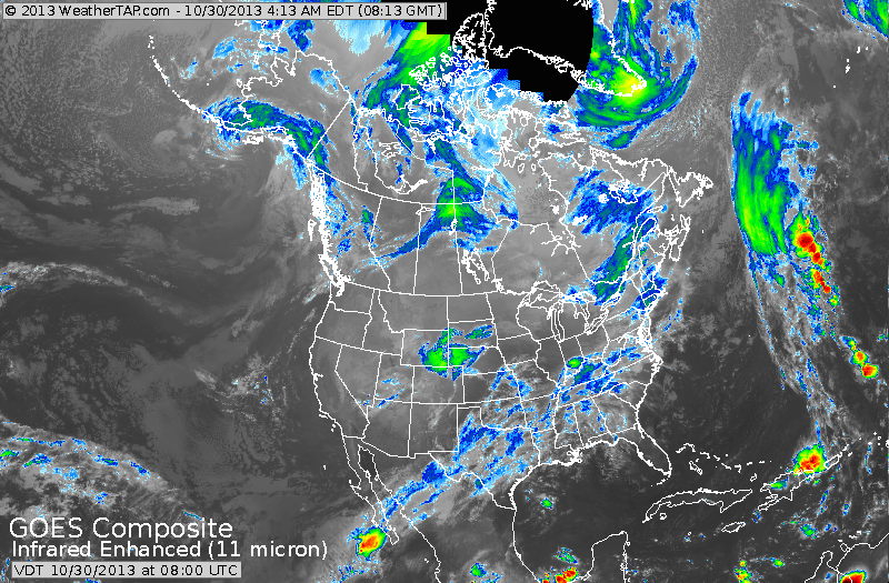
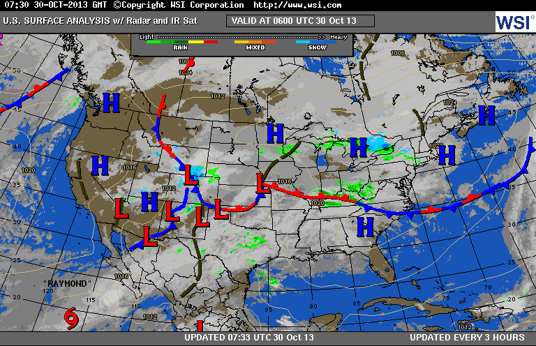
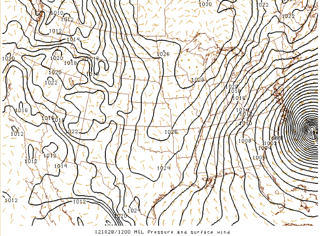
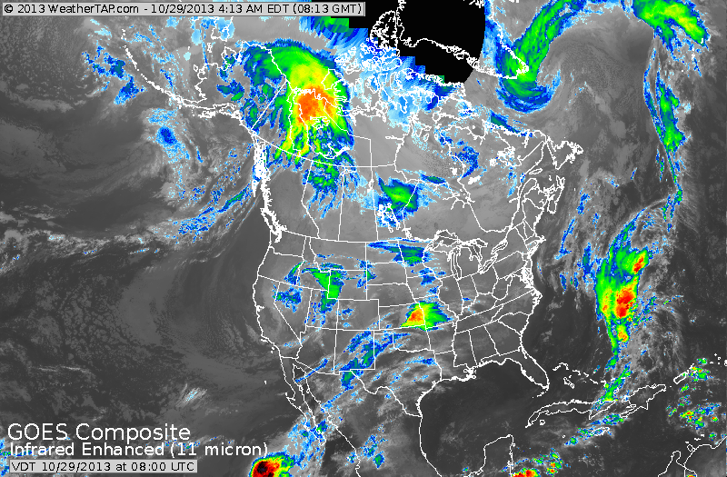
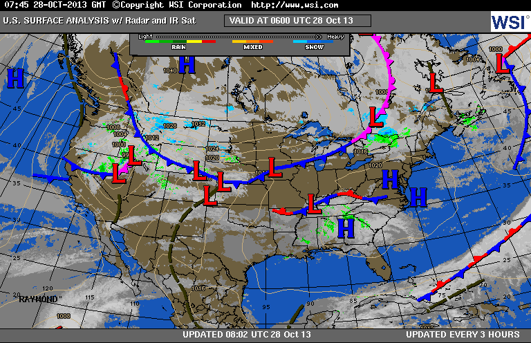
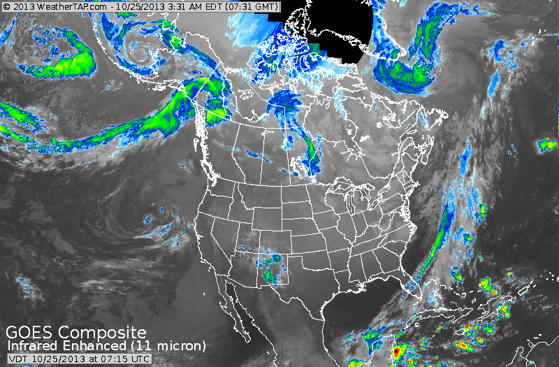
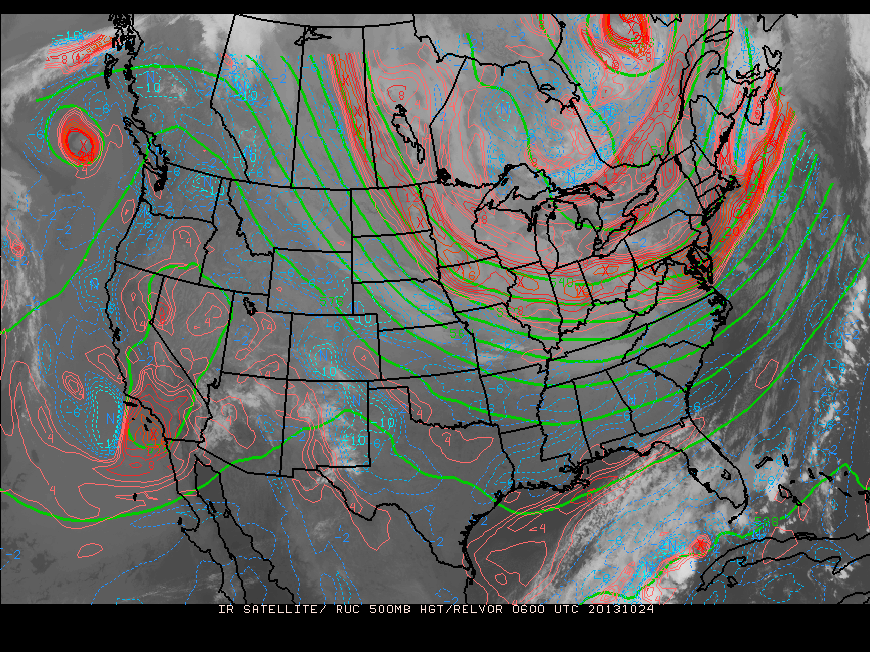
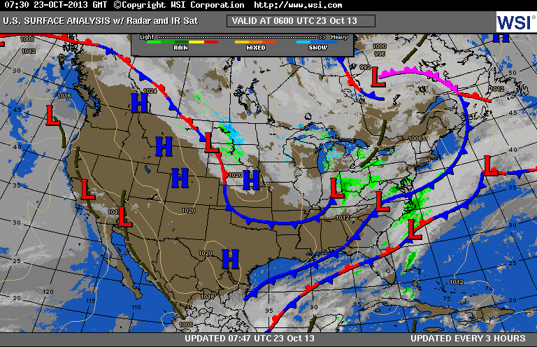
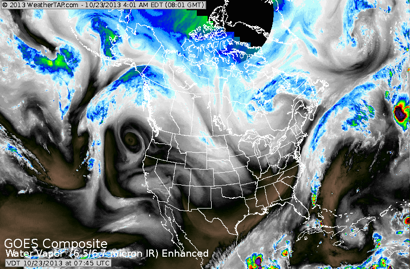
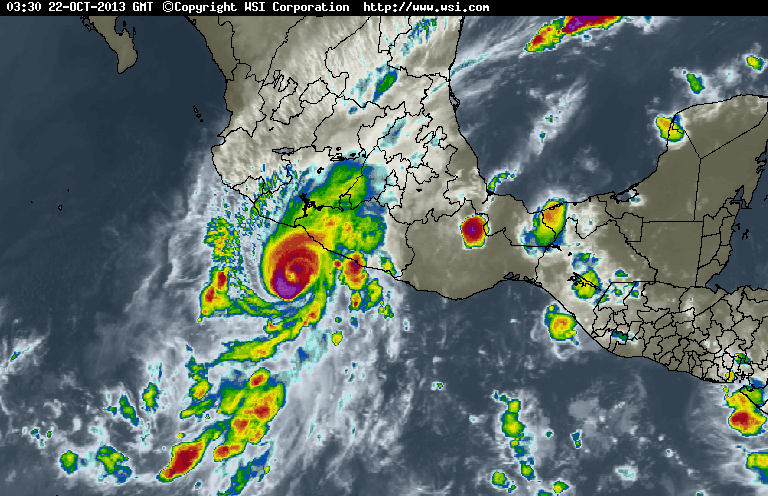
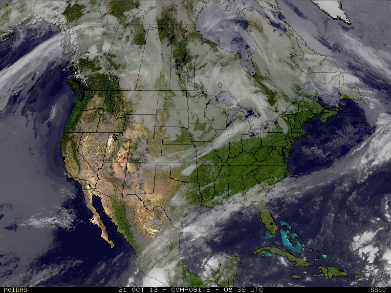
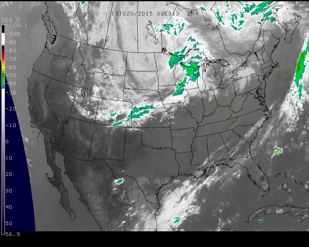
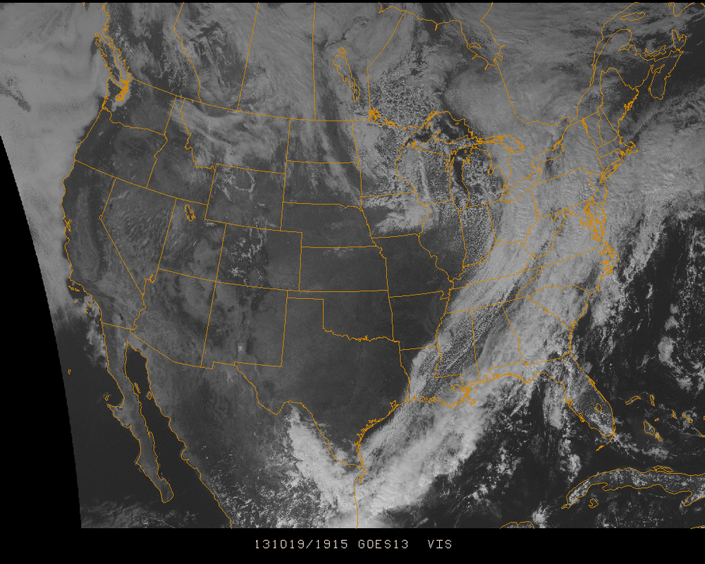
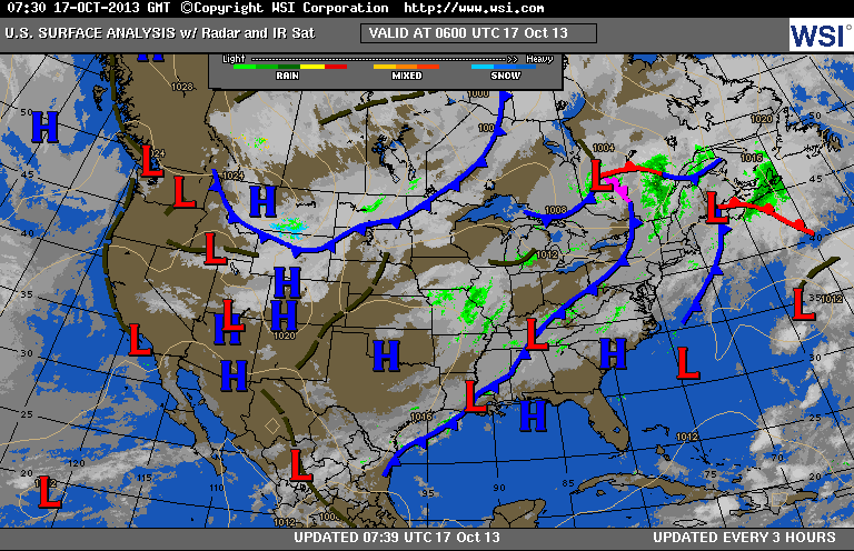
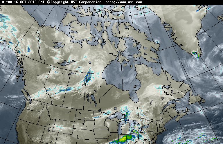
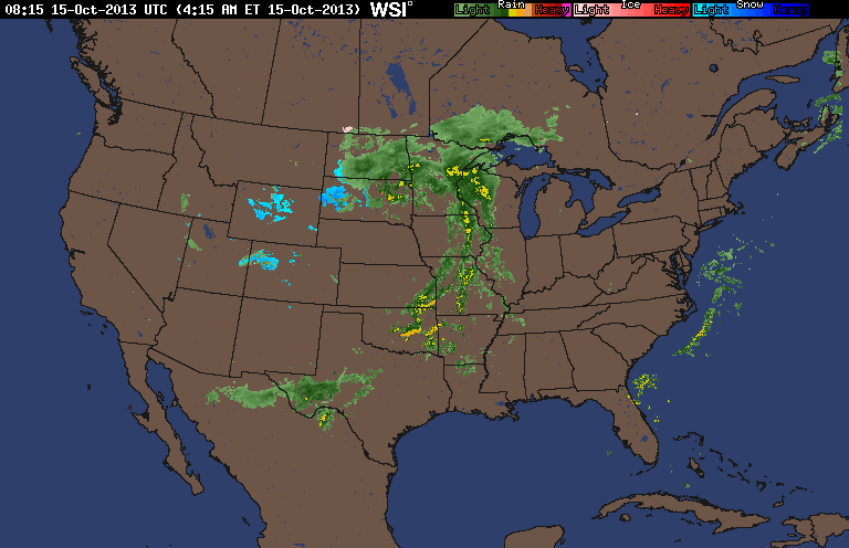
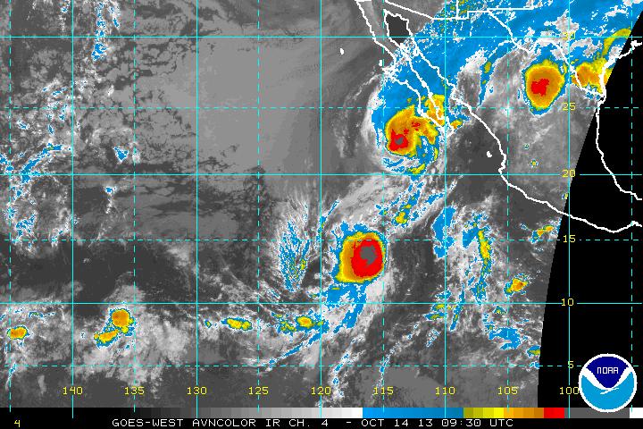
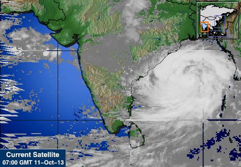
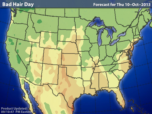
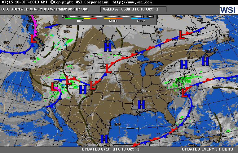
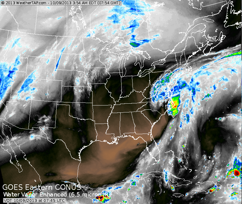
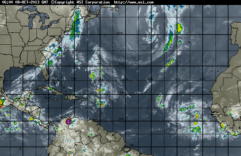
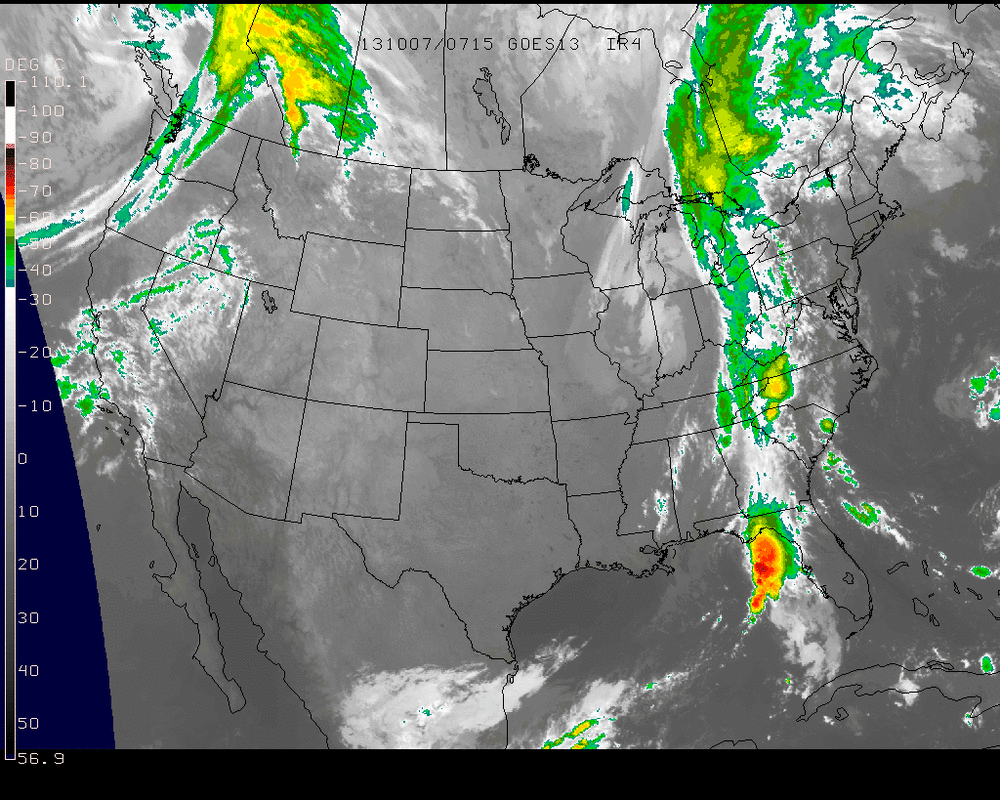
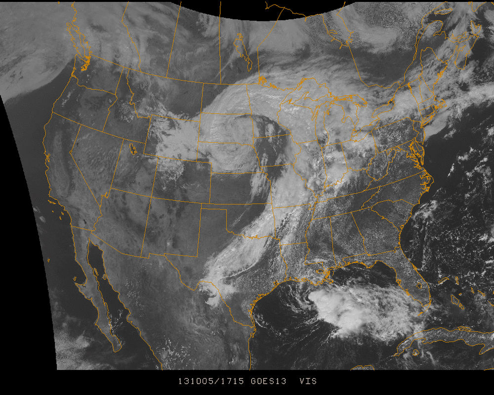
This satellite picture clearly shows the storm and front moving out of Plains. Very heavy rains for Great Lakes...thunderstorms in Texas. Below....area of severe weather today.....trick or treaters stay alert. 
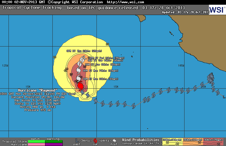
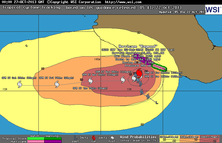
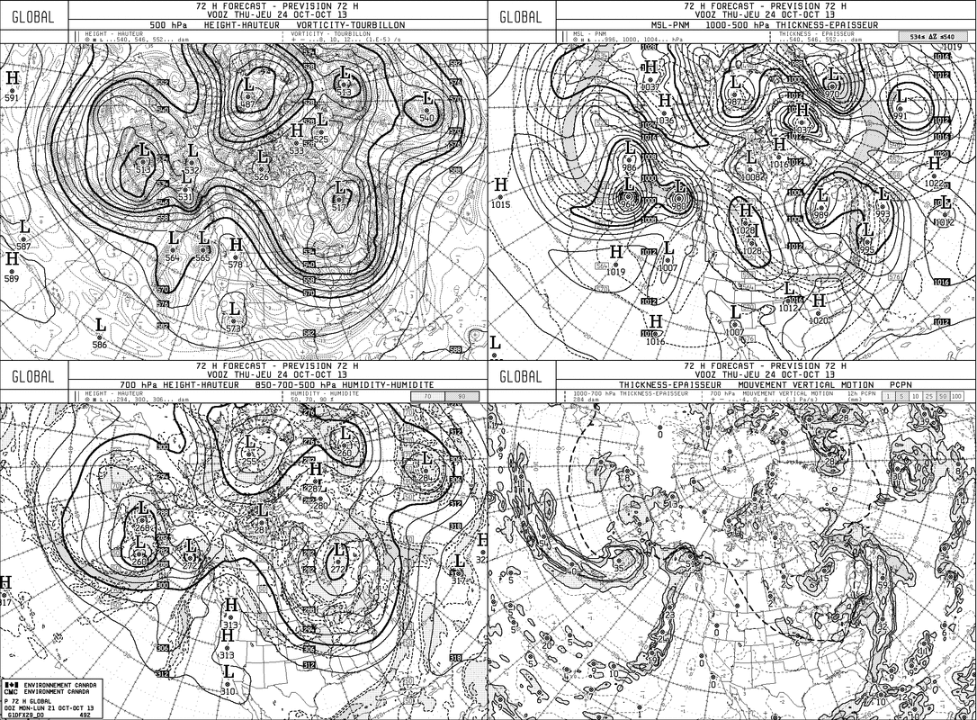
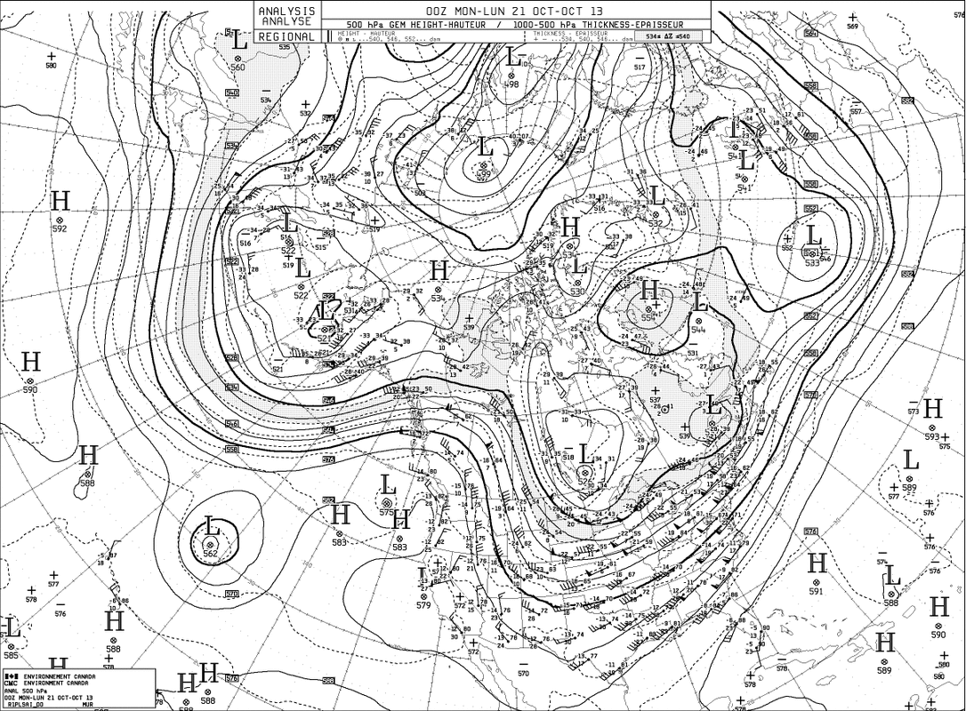
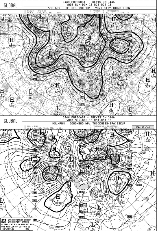
Do we believe The Canadian Model ? Is is forecasting some sort of a tropical system to hit Florida next week at this time. They have tried this before and failed this season....but they have been insisting on this all week. No other model even comes close to this. 
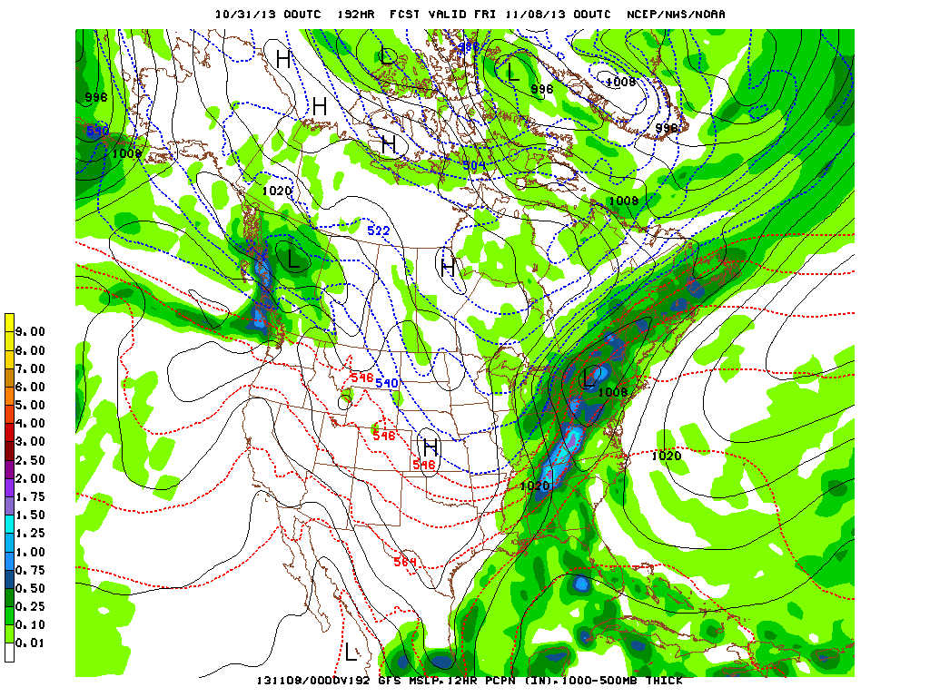
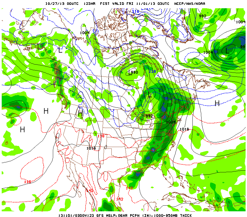
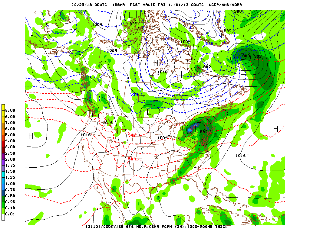
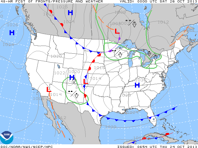
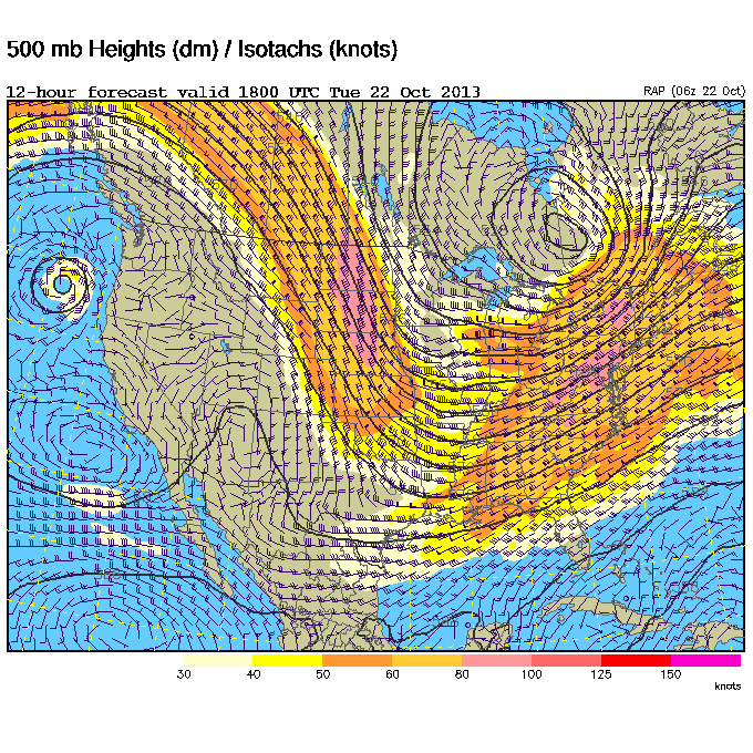
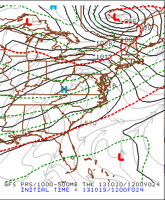
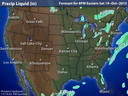
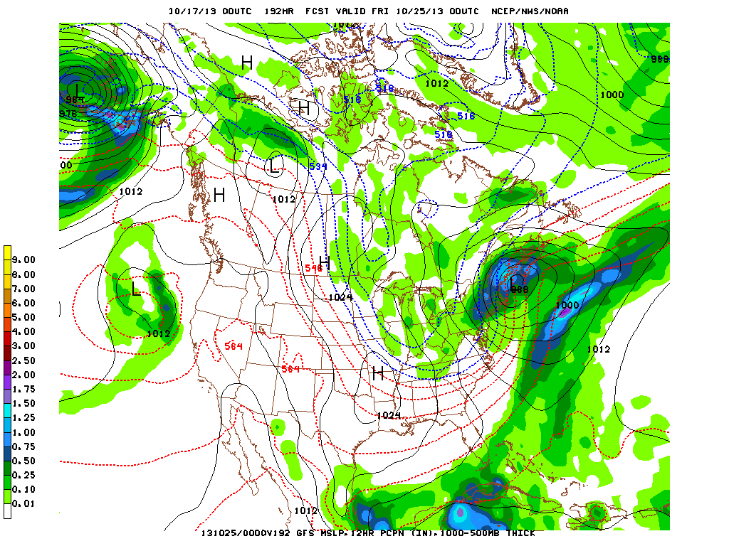
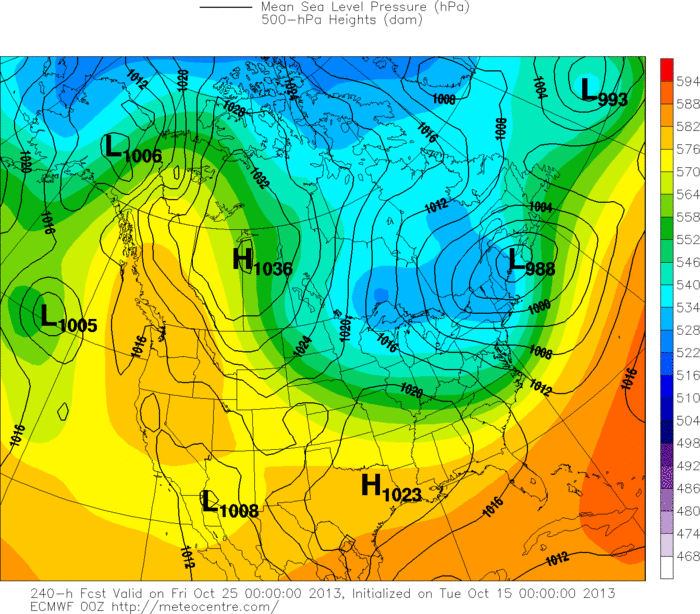
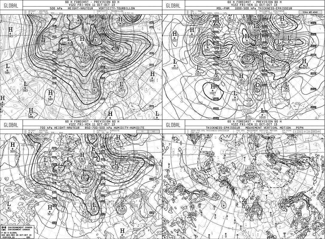
Lastly....The GFS Model being very robust with the next system flying thru the nation mid part of next week and exiting east coast late week...with even some snow on it's heels. Much needed rain comes to the East tomorrow...and then look for progressively cooler weather this weekend into early next week. Later.
0 Comments
The above map is valid for 8pm Thursday...so halloween day and night will be quite soggy from Great Lakes down to Gulf...and over to the northeast. This chart shows the area of thunderstorms in green...with severe possibility in yellow....all valid for Thursday. The chart below shows expected amounts of rain for Thursday's trick or treaters. Blue equals at least 1".....brown - 1 1/2 "........light green.....2" Below...satellite shows how Tropical system Raymond in the Pacific is sending moisture into the Plains....thus the reason for this storm to produce locally heavy rains as it moves across The Nation. Last picture is our weather map...showing extensive clouds across the Nation. Later.
A year ago Superstorm Sandy hit. This site will be dedicated to this event. Above...satellite showing the center of Sandy east of Delaware coast. Below...just pictures and chart of the superstorm. Satellite picture above is this morning's view...winter like storm in Rockies pushing into mid section of Nation. Many of maps and pictures above courtesy of National Weather Service.
Satellite pictures show the beginnings of a new storm in The Rockies...but elsewhere..not much. Keep you eye on the lower left of the screen...Hurricane Raymond. Turning north then northeast and even though weakening...his moisture will get caught in jet stream and head across the Nation with next storm and cold front. It should bring some much needed rain to a good part of our Nation by late week. You can see the clouds from Raymond fanning across So. Baja Ca., and Mexico.....while the next storm enters Utah and Wyoming. Top map...Raymond and his expected track. Just above...Satellite pix showing Raymond....still a well formed storm. This chart shows amount of precipitation that could fall from Thursday into Saturday morning. Blue indicates 1"....Gulf Coast gets 2".....most other places receive at least 1/2" or more...making it the most generous event in quite some time over a large portion of real estate.
Later. It looks like we'll have a pleasant week ahead of us, with the biggest variation being the temperatures. But as far as they go, many areas in the Northeast hit record lows yesterday. With high pressure bringing a chair and sitting down in our area we'll see a large amount of sunshine for much of the upcoming week. But if you take a look at the model below, come Thursday night approaching midnight that will all change as we'll see rain, some of it heavy at times. Other than that, we're eerily quiet now that the isolated instability has made it way through and we're simply keeping an eye on the clipper as it moves through.
A quick look at the tropics show that they're still quiet on the Atlantic side but already up to R in the Pacific (Raymond). A sunny week is a good week. Enjoy it! -Mike Merin Aside from some lake effect showers.....showers across Florida and The Southwest.....much of our Nation calm and quiet. Last year at this time we were getting ready for Superstorm Sandy....happy to say even the tropics are asleep. All the shades of blue above indicate where frost or freeze conditions are expected. Over the next 10 days ...the most significant event is a storm that moves
from The Midwest to The Northeast mid and late next week. This will be mainly a rain event...with some thunder down south. Until then...relax and enjoy your weather....later. The light grey shows mid deck clouds stretching from the Plains thru The Great Lakes...Ohio Valley into the Appalachians. Some of these clouds will produce light rain and snowshowers....otherwise a quiet time expected. Below is the latest upper air chart showing that large trof over The East....symbolizing the chilly air. Not much change as the first map below is valid for Friday nite/ Saturday a.m. when we see high pressure as the dominate feature. The next cold front moving into the Great Lakes will just serve as a reenforcement of the cool dry air. Last map is a satellite...showing Raymond finally moving away from The Mexican coast. Notice the other area of enhancement along the North Coast of South America. That could be the next tropical storm...if so..would be given the name Melissa. Enjoy the day...Later.
Low over Ohio Valley and N. Carolina will move offshore and give a glancing blow of some rain in the northeast. After that...chilly weather but dry...dominates the eastern 2/3 of the nation. This water vapor satellite shows where the dry air is....black and brown. The color reflects moisture...clearly not evident across The U.S. The swirl off The Pacific Northwest is a signifcant storm that will slide south and weaken. Snowfall map shows a couple of inches on the ground in upper Midwest...otherwise if you want to ski...head for the Rockies. Map below shows the jet stream....and you can see how it has advanced east and covers the Nation with chilly air.
A cold front extends from Eastern Gt.Lakes to Texas as you can clearly see on this satellite picture. Moisture is working northeast from the Gulf and the 2 will combine to bring some wet weather to the East Wednesday. After that...the flood gates open to chilly air. This map shows the jet stream barreling down the Rockies and then it turns toward the Carolinas. This pattern is the one that will result in chilly weather for 2/3 of The Nation. Hurricane Raymond is sitting just south of Acapulco with 120 mph winds. Region is getting hit with tropical rains and it is still predicted to move west slowly.......but animated satellite show it jogging north.
Tropical Storm Lorenzo in Atlantic moving away form coast. Be safe...later. The bright line of white over the Great Lakes is the next cold front to swing off the East coast. Cold air moving in behind this front and that combined with a small low could bring some snow to parts of The Northeast Wed- late or at night. This is the Canadian Model for Wed.nite. Upper left...shows jet stream which is carving out a trof over the Eastern half of the Nation. Upper right shows that small low near Cape Cod which could bring some wet snow to higher elevations of New England. This is the current upper air chart. The jet is moving down the Rockies
and then out to The Carolinas. This trof will continue east and result in below normal temps for much of The Eastern Half of The Nation from mid week on. Things will moderate over the weekend. Later. Low pressure traversing across the northern plains has brought down much colder air from Canada, resulting in spotty snow showers in the same US region. The spread of the clouds can be seen on the above infrared image from Saturday afternoon. Areas of precipitation have moved across North Dakota & Minnesota, as a rain & snow mixture in various locations.
This low pressure will continue to spiral eastward and pass through the Northeast on Wednesday. After this, we will see a brisk end of the week throughout the northeast region. Nothing like the daytime high 30's seen in the north central, but brisk 40's & low 50's into the weekend with clear skies. - JL It is appearing more and more like we have reached that point in which the light jackets will have to be considered on most days at some point, or at least no more shorts. Currently, most of the cloud cover in the US is secluded to the Eastern region as seen in the below visible satellite imagery from this afternoon. Low pressure can been seen centered in the Great Lakes Region along with its associated cold front traveling down to the Gulf. The rainfall along the east coast will be scattered in nature. The above image is the GFS output for Sunday morning around sunrise.The tightly packed solid black lines represent a tight pressure gradient which suggest a breezy start to the day. As the blue H representing High Pressure moves in though, winds will calm into Monday.
The week itself for the Eastern US will have one more hiccup midweek with the chance for rain on Wednesday whereas areas closer to the Great Lakes will have the chance for on & off showers much of the week with another cold front passing early in the week. Once we reach Wednesday, brisk Canadian air that moves into the region will result in max temperatures in the 50's for the remainder of the week. Take care & be well This map shows the upper air wind flow. A large trof covers much of The Nation...and it is beginning to transport cold air into the Rockies. In time..it will get progressively colder next week thru the end of the month. Don't think it will stay like that...as it may again get milder in early November. This map shows how the surface temperatures correspond to the upper air winds above. The only warm weather is the southwest and southeast. What's up for your weekend ? Above... precipitation areas for Saturday. Not many...and where there is...quite light. About the same applies for Sunday. Have a nice safe weekend....later.
Looks like a busy map...it is and will get busier next week. Cold front over Appalachians will weaken. Cold front over Northern Plains will head east and bring cooler air to The East late weekend and early next week. Progressively chilly air will head south into The U.S. next week so the month will end on a colder note...even wintry in places. Tropics...still quiet. Area in south central Atlantic still some concern...but nothing jumping out on us. The above model map is the GFS valid for next Thursday. Why am I showing you this ? It is the only model indicating a wintry nor-easter for The Northeast. This model wants to bring snow to the northeast...but only model doing so. I am not ignoring it....as I have seen this pattern
before and it can happen...but odds are not high. Even if the model is wrong....the trend to much colder weather is quite likely by this time next week....so we are preparing you. Later. The front moving into Ohio Valley will weaken and it's showers will dot the East Coast. Next front in Central Canada will bring chilly air to Northern Plains this weekend...and then to the Northeast. The Canadian satellite pix shows the cold front moving south and it will bring chilly air south next week. We expect re-enforcing fronts to keep the chilly air in place. The map above shows how precipitation will average over the next 10 days.....dry....most of the nation. Tropical analysis does not show anything associated with cloud mass off African coast...but it is our opinion - that is the area to watch...which we will be doing. For now...be safe...Later.
Both coasts are clear....mid nation cloudy and wet....some snow higher elevations of Rockies. Most of the Nation will be above the average this week. Morning radars show the wet weather from Upper Midwest to Texas....the blue indicates snow. Tropics quiet....and there are no indications that will change any time soon. This is the European models for 10 days out...next Thursday. The low off coast of Maine ushers in some unseasonably cold weather from Great Lakes to Mid Atlantic. Most medium/long range models are in agreement with this pattern. This would also indicate that lake effect snowshowers will fall from The Great Lakes to New England. With the ridge built up thru Western Canada....the west stays warm and the east
gets cold...and colder....so prepare now. Later. Wave after wave of clouds will make their way across the northeast at different times throughout the week. Near the NY metro area today we'll start off with 40% cloud cover steadily increasing to 70% Tuesday morning before it drops back down Tuesday afternoon which is when the climb will repeat itself. Wednesday will be filled with clouds as we have a chance of showers during the day and especially for the night. Thursday will go back and forth and then Friday should be filled with sunshine. Plot the cloud cover % onto a graph and it would make a good roller coaster ride. While the Atlantic is now fairly quiet (the storm system that had a chance of becoming Lorenzo hit a large area of dry air that destroyed it before it got started), the Pacific has two systems right next to each other: Octave to the north and Priscilla to the south. Priscilla will be absorbing the energy from Octave and getting stronger but will move offshore to the west. Octave should affect the southern US before dissipating.
In the middle of the nation there are areas of snow in the central Rockies, with areas of heavy rain just to the northeast closer to Minnesota. For us though in the Northeast, we'll enjoy -Mike Merin Not many people usually get off for Columbus day, but with the shutdown there will be more who will be able to go outside, so what will they be looking forward to? Here's the GFS model for Monday morning at 8am EST: For the northeast there's a trailing cold front that should dissipate by the time it gets to central NY state with the Adirondacks. There's still a stalled low pressure system off the edge of NC, the snow that's plaguing the southern Rockies will remain, and plenty of instability will bring heavy rain to central TX and parts of OK. You can actually see on the bottom left of the picture the next Pacific tropical system which has a 50% chance of becoming Tropical Storm Octave. Speaking of the tropics though: Here's the latest snapshot of the tropics, with the area highlighted being the greatest chance of becoming Tropical Storm Lorenzo. More info will come out once it becomes more organized. Finally why we're not seeing the large amount of rain that's currently over DC and its surrounding area: the system knows who deserves to get rained on. No just kidding, here's the reason: High pressure shears away any precip that tries to get north of NJ so we're in the clear. We'll keep an eye on the possibility of Lorenzo forming, but other than that the NY metro area will have a long string of sunny days with similar temps each day. Enjoy it.
-Mike Merin Superstorm (hurricane) a category 4....will hit the coast of India this weekend. The area is heavily populated and the storm is expected to pack 150 mph winds. Closer to home...system off Africa is trying to grow...but will meet many negative factors including dry air ahead of it. It could become Lorenzo...when and for how long...very questionable. The GFS model for end of October....hinting at a major shift. Jet stream
plunges down to Gulf...bringing snow and cold air to Great Lakes and into New England.....while west warms up. So if you need to decide on a halloween costume and you live anywhere east of Mississippi....think warm. Have a nice holiday weekend....later. Early a.m. radar shows rain from Southern N.J. to coastal North Carolina. Yellow and orange...heaviest. Still feel heaviest rain from NJ to Va. Rain will move north to Southern New England but in lighter fashion. If you live in the green area....don't worry about your hair today....otherwise orange.....use a good gel. Still watching tropical wave off AFRICA which could already be a depression. Hurricane center giving it a 30% chance of growing. It could become Lorenzo....but it will be fighting lots of opposing forces. You can see the storm along the N. Carolina Coast.....and a new stormin the Southern Rockies. Much of the Nation under clear skies. Have a nice one...later.
The satellite pictures above show lots of dry air over the nation...(black and brown).......but notice the comma shaped pattern along the East. This low will play games with mid-Atlantic and New England for rest of week. The cut off line between rain and lots of rain and no rain will be sharp. Vermont/ New Hampshire/Maine may not see a drop...while Boston and Hartford get drizzle...and Long Island down to Delaware get flooded out. This chart shows total rainfall by Friday morning. 1-2" from southern New England to Mid Atlantic. Personally....think it's overdone in the north...and expect the heaviest rain from NJ on south. This 4 panel chart may be hard to see......but it's The Canadian....who
bombs the mid Atlantic and Southern New England with rain. It usually is overdone...but it has been insisting on this all week....so perhaps it could be right.....but I still have my doubts. More tomorrow. Later. Cold front off the east coast was responsible for severe weather in The Northeast yesterday. High pressure builds east but see that low over Coastal Georgia...it could bring clouds, cool, damp weather back to Mid Atlantic & Northeast late week. Cold front over Montana will hopefully bring a return to nice weather for holiday weekend. Hurricane Center giving disturbance off Africian coast a 40-50% chance of growing into Storm Lorenzo over next few days. Aside from that...Atlantic is amazingly (scary) quiet. Later.
Can you find the cold front ? It stretches from Detroit to Atlanta. The bright orange in the Fla. panhandle is what is left of Karen. You would think with all that sunny weather in the Nation that everyone will have another nice week of weather....not quite. Squeeze play for Northeast and MidAtlantic. High in Eastern Canada...front off Carolinas...sets up onshore flow. Cut off line for clouds..rain and drizzle could be Vermont/N.Hampshire by mid and late week....then it may push south for weekend...but how far ? top panel: Upper air... notice High over Eastern Canada and right below it...Low. Bottom panel....same set up. It could mean grey and wet from Long Island South...or Delaware south....hard to say. Next system working across Plains will weaken with time. Watch these areas off Africa. Either one of these could become the next tropical storm...if so....it would be named Lorenzo. Later.
The cold front that sheared apart Karen didn't just get rid of her, it absorbed her energy and moisture. Although Karen is now labeled as a tropical depression and is unorganized she still has plenty of moisture to feed the cold front. You can see on the surface map below the front and what's left of Karen. Remember how winds move along the front edge of a cold front: towards the low. This means that there's southerly winds drawing up all the moisture inland, and because the cold front has a very large gradient, those winds are very strong. What does this mean? Well take a look at the models below. These are 12 hour increments starting from today at 2PM EST. You can see just how much moisture the front is drawing in. Add that onto the moisture the atmosphere already had in it, and the front raising that moisture into the upper atmosphere condensing it into heavy rain, and you can see why many areas will have a large amount of rain and strong thunderstorms as it sweeps through, and why we'll have a 1-2 inches of rain in the metro area from Monday afternoon into Tuesday morning, more in areas of thunderstorms.
Good news though? After that it's sunshine into the weekend. Stay dry until then. -Mike Merin It has been a really dry start to the season for the Northeast with sunny day after sunny day with a few clouds and more sunny days. Temperatures have touched 80 again in the past couple of days in the NY Metro area. There are a few noticeable features in this afternoon's US visible satellite imagery... 1) Tropical Storm Karen down in the Gulf of Mexico. It's movement has been quite erratic but its future path will be influenced by our #2 feature 2) The Low Pressure system centered in the North-Central US. This storm has brought so much snow and blizzard-like conditions that you can make out most of Wyoming on this map covered in snow. Below is a closeup of the North Central for better view of the snow. It will be much easier to see the snow on the ground in areas such as South Dakota & North Dakota tomorrow when skies are expected to be clear. Our 3rd feature is a subset of the 2nd feature... The warm/stationary front pushing east across the Great Lakes. This will continue to spawn sporadic showers and thunderstorms in the region in wake of the more consistent rainfall expected Monday into Tuesday for the eastern US.
The exact path of this system has been very inconsistent from model to model so it is still quite uncertain the path this system will exit the region late Tuesday and if some areas closer to the ocean cease seeing rain by Tuesday afternoon or Tuesday overnight. A few days ago, Karen appeared as if it would beat the upper low into the east and bring an even higher rainfall to the eastern seaboard. Its current path has it riding the south end of the cold front across Florida before stalling off the Carolina coastline and weakening even more... We will be closely monitoring all of this as it unfolds over the next 48 hours into Monday. - JL |
We'll have daily weather discussions, talking about major systems on the horizon along with anything noteworthy that pops up on our radar.
Pat Pagano,
|