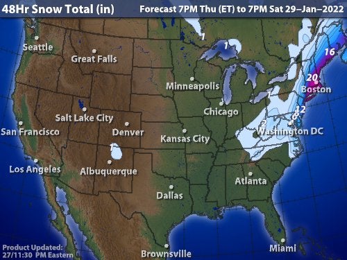
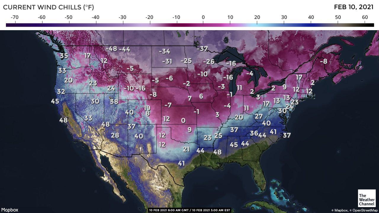
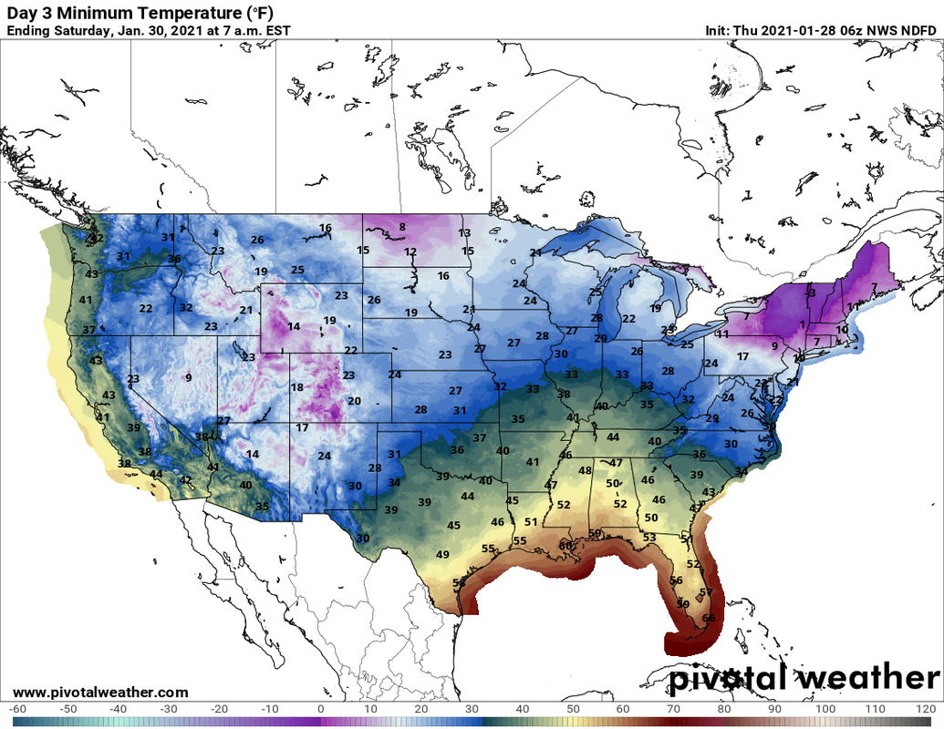
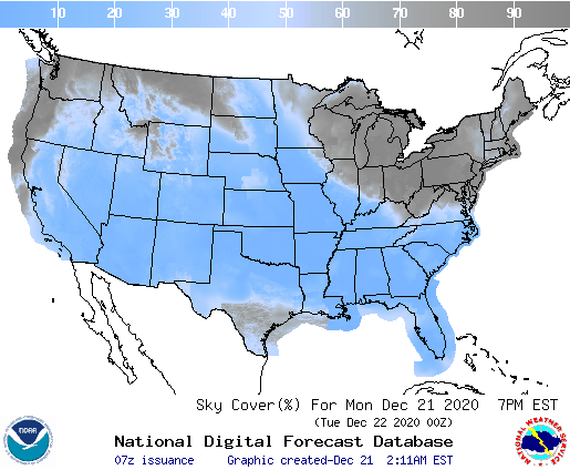
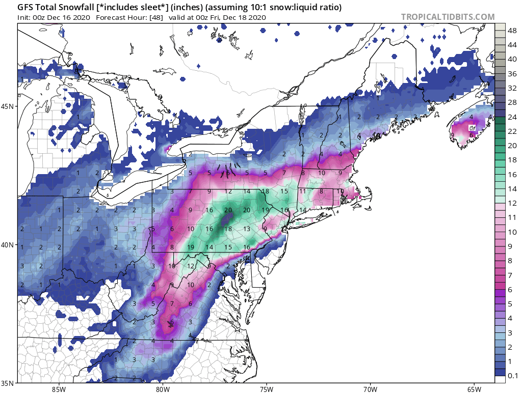
Above...satellite + radar show plume of wintry precip from Gulf to Northeast. Many places will see 6" or more of ice from Appalachians to New England. Cold for Central U.S. - warming up west coast but unsettled for Northwest. Below - snowfall through Friday....Rainfall through Tuesday....animated maps next 2 days. 
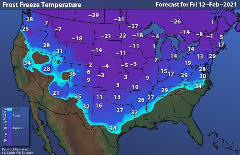
below- snapshot weather for Friday. Be safe !
0 Comments
Above - map projection the cold for this Friday. Below - snowfall thru 48hrs.....animated maps.....rainfall into Wednesday...satellite + radar. These maps will show one storm after another sailing across the Nation and turning up the Eastern States. All of these storms bringing ice and snow to the north...rain south. Below - snapshot weather for Saturday. Be safe !
Above - early morning wind chills. Below - satellite + radar - snow outlook through 48 hrs - rainfall into Monday and animated map for next 2 days. Below - snapshot weather for Thursday. Be safe.
Satellite + radar above shows storm taking shape off Virginia Capes...turning to nor'easter which will drop 1 to 2 ft of snow from New York Metro Area northward. Winds will gusts over 50 mph resulting in blizzard conditions. Storm will gradually weaken during Tuesday as it moves out into No. Atlantic. Below - snowfall thru 48 hrs...animated maps....rainfall into Saturday.
Above.....projected low temperatures for SATURDAY MORNING. Below - Satellite + radar showing a winter storm moving off the Carolinas and a larger storm along the West Coast. That storm hits the Midwest Saturday...heading for The East Sunday into Monday. Below - snowfall thru 48hrs....animated maps...rainfall through Tuesday. Below- snapshot weather for Friday. Be safe !
The storm that affected the East is moving out across New England. The next storm over Gulf States will move out across the Carolinas by Thursday morning. Frigid air now in the Upper Midwest movesinto the Northeast Friday - Saturday. Next storm along West Coast bring rain - snow and wind ....it heads east and will affect the East Coast by early next week. Below - snow forecast thru 48 hrs.....animated maps...rainfall thru Monday. Below - snapshot weather for Thursday. Be safe.
Storms continue across the South....as cold fronts continue in the North. Don't see this changing for the next 5-7 days. Below - 48 hr. snowfall...animated maps - rainfall into Tuesday. Snapshot weather for your Friday. Be safe.
Satellite + radar above showers snowshowers from Daktoas to Northeast...rain and snow in SOuthwest to Ohio Valley. These areas are light and no big storms yet. Below - snowfall next 48 hrs - animated maps next 2 days - rainfall thru Saturday Below- snapshot weather for Wednesday - Inauguration Day. Be safe !
Satellite + radar above clearly shows 2 jet streams...north and south. Until they merge...weather changes little. System coming across the Rockies will be a big wind producer. It will reach the East Coast this weekend. Below - snowfall thru 48 hrs---animated maps - rainfall through Sunday. Below - snapshot weather for Thursday.....please be safe.
Another storm stays south...could bring 2"-4" of snow to Louisiana and Arkansas. New storm in the Pacific Northwest....otherwise quiet. Below - 48 hour snowfall......animated maps....rainfall thru Saturday. Below - snapshot weather for Tuesday.
Satellite + radar above: Storm moving through the Carolinas will drop rain and wet snow today before moving out to sea. Next system along west coast will head south and bring more rain to Gulf States early next week. Very quiet weather continues....many places have received far less snowfall than normal for this time of year so far. Below - snowfall thru 48 hrs....animated maps....rainfall into Wednesday. Below - snapshot weather for Saturday. Be safe.
Satellite + radar shows next storm in Gulf States. It will move across Carolinas and out to sea by Saturday. A new storm enters the West Coast..it can arrive along the East Coast by next Tuesday. Below - snowfall thru 48 hours....animated maps.....rainfall through Tuesday. Below- snapshot weather for Friday. Be safe.
Animated maps above show storm #1 in Plains dropping south to Carolinas and out to sea by Friday. Storm # 2 drops to Gulf States and it will try to come up East Coast next week. Below - satellite + radar - snowfall thru 48 hrs - rainfall into Tuesday. Lastly - snapshot weather for Thursday.
Radar/satellite picture above shows the remnants of the weekend storm moving out across New England. A front cross the Plains could bring some rain or wet snowshowers to the East Tuesday - otherwise most of the Nation on the guiet side. System along the west coast will move across the south. Below - snowfall through 48 hrs - animated maps for next 2 days - rainfall into Saturday. below- snapshot weather for Tuesday.....be safe.
Satellite + radar above shows a cold front from New England to Texas with mainly rain. That sinks south and a storm form in the Gulf and moves north to bring rain back to East Friday into Saturday. System in the Northwest heads east to bring rain or a wintry mix to Northeast Sunday. Below - snowfall thru 48 hrs - animated maps....rainfall into Tuesday. Below- snapshot weather for Friday - a happy - healthy and safe New Year to all.
Some lake effect snow and colder for Northeast. Storm heads across the Plains to Upper Midwest producing 3"=6" of snow there. That storm bring a touch of rain to East Thursday. A second storm will bring a wintry mix to New England on New Year's Day....rain elsewhere. A third and sneaky storm could bring some rain a/o snow to Northeast thereafter. Below.. snowfall thru 48 hrs.....animated maps....rainfall through SUnday. Below - snapshot weather for Wednesday. Be safe.
Above - storm pulling out of the Southwest heads for Great Lakes with snow again - west of the track. That system brings rain to East by end of this year. A second storm forming on the end of this front will bring more rain to East on New Year's Day with a wintry mix in the Northeast..where some places could get icy. Below - snowfall thru 48 hrs...+ rainfall through Saturday. Ending with snapshot weather for your Tuesday. Please be safe.
Above....satellite + radar shows a strong cold front from Great Lakes to Louisiana. Thunderstorms in the South...heavy rain and strong winds...all moving to the East Coast tonight and Christmas morning. Ahead of it..unusually mild...behind it...noticeably colder. Below - snowfall over next 48 hours..animated maps - rainfall through Tuesday and severe weather for today and tonight.. Below - snapshot weather for Christmas Day. From the weather center to all...a very Merry and Safe Christmas.
Storm in the Plains will bring snow and wind there today...and then as it heads east...wind - rain for The East Thursday with severe storms over the Gulf States today - Carolinas Thursday. Winds could gusts over 50 mph Thursday night in Northeast. Windy and much colder Christmas Day with lake effect snows. Below - snowfall through 48 hours...animated maps - rainfall through Tuesday. Below - snapshot weather for Thursday. Be safe.
Satellite - above - shows some rain and/or snowshowers in Northeast....all of which will taper off . Next storm coming into Northwest will drop several inches of snow in Norther-tier...then bring wind and rain to the East Thursday...followed by sharply colder for Christmas Day. Below - snowfall thru 48 hrs, animated maps thru 48 hrs - rainfall into Sunday. Finally - snapshot weather for Wednesday. Be safe !
Above...map by The National Weather Service shows where skies are expected to be clear for viewing The Christmas Star or Jupiter and Saturn together. Has not been seen since the 1200's. Best time to see it...1 hour after sunset in the southwest. Below - current satellite & radar.....showing some rain and snow diving through the Great Lakes and moving into the Northeast late tonight. Below - snowfall through 48 hours - animated maps for next 2 days - rainfall through Saturday. Snap shot weather for Tuesday. Be safe.
Above- satellite + radar shows a cold front moving through the Plains. That front will bring some rain and snowshowers in its trek across the Nation...arriving on the East Coast Sunday. Below...snowfall through 48 hours.....animated maps....rainfall through Wednesday. Below- snapshot weather for Saturday. Be safe.
Winter Storm in Northeast will be winding down today. Anywhere from 4" to 24" has fallen thus far...and a few more inches are still possible. Some places reported 5" of snow in one hour. Another front causes rain and snow in the West otherwise much of the Nation...fair and cold. Below...wind chills this morning...animated maps....and rainfall through Tuesday. Below- snapshot weather for Friday. Be safe !
Above - GFS Model prediction of snowfall over next 24 hours. It was the last model to join in predicting double digit snowfall. Along the NJ Coast and Long Island...snow tonight will mix or change to sleet and rain for a time resulting in lower accumulations otherwise...6"-12" on the average with 15"-20" interior New England and Lower Hudson Valley. Dangerous storm tonight..all travel should be avoided. Below - 48 hr. snowfall - animated maps - rainfall through Monday. Below - snapshot weather for Thursday. Be careful and safe.
Satellite + radar above shows cold air over Great Lakes moving east. A storm in So. Plains will head northeast and becoming a major nor'easter Wed.night and Thursday. Storm will deliver strong winds and heavy snow from Appalachians into Northeast. Many places will receive over 1 foot..especially from Pennsylvania to So New England. Below - snow fall over the next 48 hrs., animated maps, rainfall into Saturday. Below - snapshot weather for Wednesday. Be safe.
|
We'll have daily weather discussions, talking about major systems on the horizon along with anything noteworthy that pops up on our radar.
Pat Pagano,
|