By now everyone knows about Andrea, especially in Florida where it's currently bringing high winds and downpours, even tornadoes in some areas. The question is, where will it be moving and how will it affect you?
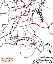
Before I answer that, just a quick look at the storm and what's around it to get an understanding of it all. First up, the current surface map is just to the left. You can see the storm just off the coast of Florida, and a few fronts above it with the central Low (triple point) in Ohio.
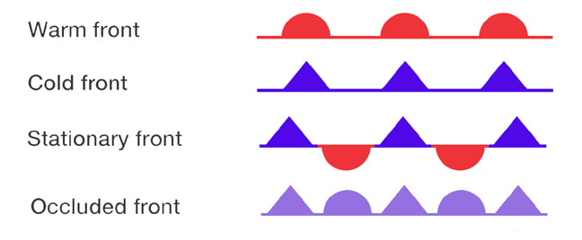
Now, those fronts will play a very important role in the positioning of Andrea. If you didn't know what all those symbols mean:
Those are the four types of fronts, or boundaries between two large air masses. A warm front means that a large air mass is moving pushing into a colder air mass, cold front is the same but pushing cold into warmer (and is usually faster), a stationary front means that two separate air masses have clashed (still moves slightly towards the warmer air) and occluded means that the cold front has caught up to a warm front and has overtaken it, with the cold air mass pushing under the warm air (cold air is more dense than warm air so it sinks) and they both mix and push ahead.
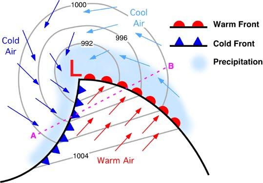
SO, next up is the winds. The main thing to keep an eye out for here is that cold front extending from Ohio into Mississippi. Why? Because ahead of a cold front, winds always move along it towards the low, as you can see below:
SO, next up is the winds. The main thing to keep an eye out for here is that cold front extending from Ohio into Mississippi. Why? Because ahead of a cold front, winds always move along it towards the low, as you can see below:
Now place Tropical Storm Andrea at the bottom of the picture, and you'll see that the winds from the cold front will be driving the storm fairly quickly through the eastern seaboard, and will also clash with the system shearing it as it goes. Shearing means there are cross winds, which cut off the circulation to the storm and weakens it (think about when you use a straw to mix a drink: when you suddenly stop with the straw and go in another direction, the neat little circular current all of the sudden loses it's form; it's sort of like that). Also, because these winds will be shearing the storm and moving it faster, that means that it will not only lose its energy fairly quickly but will also be more spread out with its energy. That means it will be more widespread but less concentrated in intensity.
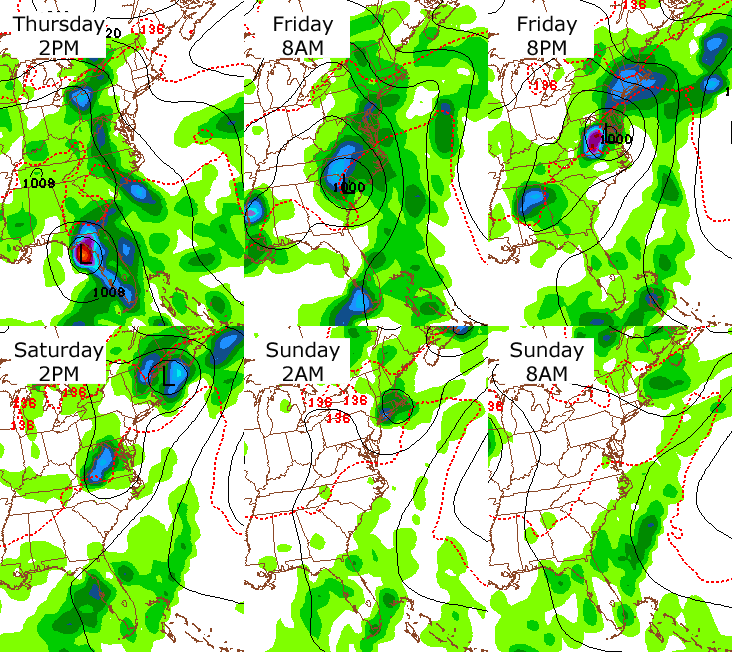
SO, with all of that said, here's the skinny on how it will most likely be moving in a simple gif below. Just keep in mind what I said above, and that the precipitation from Andrea will combine itself with the precip from those fronts, and you'll get a good idea of why there will be so much precip over a large area.
SO, with all of that said, here's the skinny on how it will most likely be moving in a simple gif below. Just keep in mind what I said above, and that the precipitation from Andrea will combine itself with the precip from those fronts, and you'll get a good idea of why there will be so much precip over a large area.

Also keep in mind that if you're in the tri-state area, you'll be getting precip from the cold front first and THEN Andrea, so frontal precip starting tonight at midnight and Andrea precip starting tomorrow afternoon/evening into Saturday morning/noon, with a trailing area of precip moving through Saturday night.
-MM
-MM


 RSS Feed
