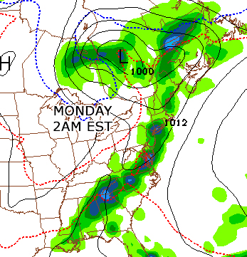
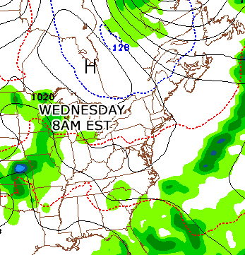
The week ahead for much of the northeast will start off with showers and thunderstorms. Sunday night into Monday night we'll see the chance of some strong thunderstorms bringing gusty winds and very heavy rains, though by Tuesday high pressure will be dominating the area. You can see the difference between Monday and Wednesday below.
 |  |
HOWEVER, that's not what's caught my eye. Looking at the tropics, the Gulf of Mexico is showing some turbulent weather, and the models are showing that there's a chance of some development into a tropical depression. That's right, week 1 of the official 2013 Atlantic hurricane season may already bring us a named system. Though not strong, it will bring a large amount of rain, winds, and thunderstorms, as well as hazardous rip-currents.
The biggest factor keeping this system together will be if the gulf winds are low enough to not sheer it apart. It all depends on how organized it can remain once it heads towards Florida. We'll keep an eye on this system as it moves throughout the week, as there's a chance it may crawl up the eastern seaboard. Depending on the direction of the how the jet stream is tilted, by the end of the week the system can either accelerate towards New England or out to sea. In either case, next weekend doesn't look like a time where you'd want to be in the water.
Below is a day by day that the GFS is pushing for Wed-Sat
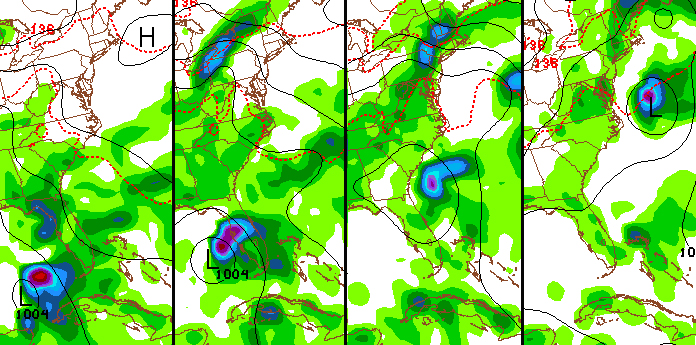
Again, we'll see how the system moves throughout the week. The Carolinas will definitely have a windy mid-week with rip-currents, but we'll have to see how close it will move near New England.
-MM
-MM

 RSS Feed
