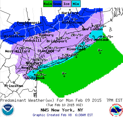
The image above shows just how complex this system is and how a 5-10 mile difference could mean a completely different type of precip falling by you. Sound familiar? Last week was the same. Difference is that this upcoming storm will have less precip embedded in it. Problem is though that that image above changes throughout the day and the rain/snow or snow/freezing rain line moves up and down, loops around, shifts, slants, etc., so the forecast once again is different for multiple locations which you can see below.
The models all agree that the low will redevelop around southern NJ instead of just above NYC, meaning that the chance for snow and freezing rain will still remain on Sunday night into Monday. With lows hovering around the freezing mark, just like last week we'll have different forecasts for NJ, LGA, JFK, Central Park, and different parts of Long Island,.
As it stands, the more south you go the greater chance of seeing rain on Monday vs. mixed precip, however again 5-10 miles with this storm north could mean more rain and 5-10 miles south could mean more snow and freezing rain. More certainty will come tomorrow.
Today into tonight and Sunday the precip will stay mostly north but there's still a slight chance of a passing rain shower, or snow shower mixed in if you're on LI.
Stay save especially where there is ice.
-Mike Merin
Central Park
Today: 40° high
20% passing rain shower
Tonight: 28° low
20% rain until 9PM
9PM-2AM 60-80% mix of rain/snow (trace)
2AM-8AM 100% mix of snow/f.rain (.25-.75", .05" ice)
Monday: 31° high
100% precip, .15-.25" liquid falling, snow/f.rain, 1-2" snow, <.10-.20" f.rain, maybe some rain but trace if any
Mon. Night: low 25°
100% --> 20% by 2AM, mix of snow and freezing rain (<1" snow, .02-.06" ice)
Tuesday: High 36°
no precip
---------------------------------------------------------------------------
LGA
Today: 39° high
20% passing rain shower
Tonight: 30° low
20-30% rain until 9PM
9PM-2AM 60-80% mix of rain/snow (trace)
2AM-8AM 50% --> 90% mix of rain/snow, trace f.rain (<.50", .01" ice)
Monday: 33° high
100% precip, .15-.25" liquid falling, snow/f.rain, 1-2" snow, <.10-.20" f.rain, maybe some rain but trace if any
Mon. Night: low 26°
100% --> 20% by 2AM, mix of snow and freezing rain (<1" snow, .02-.06" ice)
Tuesday: High 35°
no precip
---------------------------------------------------------------------------
JFK
Today: 38° high
20% passing rain shower late
Tonight: 30° low
30-40% rain until 12AM
12AM-2AM 60% mix of rain/snow (trace)
2AM-8AM 100% mix of snow/f.rain (<.50", .03" ice)
Monday: 35°
100% precip, .15-.25" liquid falling, snow with rain/f.rain flip-flopping throughout the day as temps fluctuate, <1" snow, <.02-.05" f.rain, rest rain
Mon. Night: low 28°
100% --> 20% by 2AM then 5AM, early rain/snow, then snow/f.rain (<.50" snow, .03-.08" ice)
Tuesday: High 36°
no precip
---------------------------------------------------------------------------
Newark NJ
Today: 38° high
30% passing rain shower late
Tonight: 31° low
30% rain until 9PM
9PM-2AM 60-80% rain (trace)
2AM-8AM 100% mix of rain/snow (<.50")
Monday: 32° high
100% precip, .15-.25" liquid falling, snow/f.rain, 1-2" snow, <.10-.20" f.rain, maybe some rain but trace if any
Mon. Night: low 26°
100% --> 20% by 2AM, mix of snow and freezing rain (<1" snow, .02-.06" ice)
10% leftover trace flurries until 5AM
Tuesday: High 36°
no precip
---------------------------------------------------------------------------
Northern Long Island
Today: 37° high
20% passing rain shower, possible late day sleet as well
Tonight: 27° low
30-40% rain until 9PM
9PM-2AM 60-80% mix of rain/snow (trace)
2AM-8AM 100% mix of snow/f.rain (.25-.75", .05" ice)
Monday: 31°
100% precip, .15-.30" liquid falling, snow with rain/f.rain flip-flopping throughout the day as temps fluctuate, 1-2" snow, <.10-.20" f.rain, maybe some rain but trace if any
Mon. Night: low 26°
100% --> 20% by 2AM then 5AM, snow/f.rain (.25-.75" snow, .04-.08" ice)
Tuesday: High 35°
no precip
---------------------------------------------------------------------------
Southern Long Island
Today: 40° high
20% passing rain shower
Tonight: 30° low
30-40% rain until 12AM
12AM-2AM 60% mix of rain/snow (trace)
2AM-8AM 100% mix of snow/f.rain (<.50", .03" ice)
Monday: 35°
100% precip, .15-.25" liquid falling, snow with rain/f.rain flip-flopping throughout the day as temps fluctuate, <1" snow, <.02-.05" f.rain, rest rain
Mon. Night: low 26°
100% --> 20% by 2AM then 5AM, early rain/snow, then snow/f.rain (<.50" snow, .03-.08" ice)
Tuesday: High 34°
no precip

 RSS Feed
