SATELLITE SHOWS COLD FRONT HEADED FOR THE EAST COAST WHERE IT WILL BE FOGGY...MILD...SOMETIMES WET...THUNDER AND
SOME STORMS MAY BE ON THE GUSTY SIDE. SNOWS MOVING OUT OF GT. LKS. (CLICK ON IMAGE TO ENLARGE)
SOME STORMS MAY BE ON THE GUSTY SIDE. SNOWS MOVING OUT OF GT. LKS. (CLICK ON IMAGE TO ENLARGE)
ABOVE....YELLOW SHOWS RISK OF SEVERE THUNDERSTORMS TODAY....GREEN IS GENERAL AREA FOR THUNDERSTORMS.
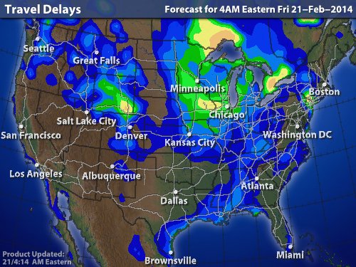
ABOVE...TRAVEL DELAYS BECAUSE OF THE WEATHER. THE BRIGHTER THE COLORS...THE BIGGER THE DELAY. GOOD LUCK.
ABOVE...INNOCENT LOOKING MAP FOR THIS SUNDAY....FOR THE MOST PART IT IS. THE LITTLE LOW ON COLD FRONT NEAR TENNESSEE COULD BRING A LIGHT SWATH OF SNOW EAST TO MID ATLANTIC SUNDAY NIGHT....AN INCH OR TWO AT BEST. AFTER THAT...PLUNGES OF ARCTIC AIR WILL CONTINUE...WHILE A WAVE TRAIN OF LOWS
SCOOTS ALONG THAT FRONT. ANY OF THESE COULD TURN OUT TROUBLESOME...HARD TO SAY NOW. WE WILL NEED TO WAIT FOR A SYSTEM TO BREAK THRU THE RIDGE ON WEST COAST AND COME EAST. THAT MAY NOT BE UNTIL LATE NEXT WEEK. UNTIL THEN...
ENJOY THE WEEKEND.
SCOOTS ALONG THAT FRONT. ANY OF THESE COULD TURN OUT TROUBLESOME...HARD TO SAY NOW. WE WILL NEED TO WAIT FOR A SYSTEM TO BREAK THRU THE RIDGE ON WEST COAST AND COME EAST. THAT MAY NOT BE UNTIL LATE NEXT WEEK. UNTIL THEN...
ENJOY THE WEEKEND.

 RSS Feed
