It seems like Mother Nature doesn't know what a proper gift is. With the winter storm slowly moving in towards the tri-state area, here are the current warnings/advisories:
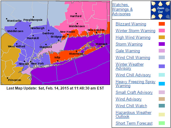
NYC, Newark, and into Nassau have:
Winter Storm Advisories until tomorrow at 1PM
High Wind Watch from tonight at 12AM until Sunday 6PM
Suffolk and southern CT have:
Blizzard Warnings until tomorrow at 1PM
High Wind Watch from tonight at 12AM until Sunday 6PM
Gale warnings for the western LI Sound and the Hudson inlet, storm warnings elsewhere over water.

With the storm currently on the radar the models have consolidated and agree on the forecast below within .50-1" or so. Right now there's mainly scattered precip as you can see above, but in a few hours it will become more concentrated over the NY metro area, delayed by an hour or so for Suffolk. Here is the current timeline:
Today:
to 3PM - 30% passing flurries, trace-.25" precip
3PM-6PM - to 70% snow showers, anywhere between .50-1” by sunset
Tonight
6PM-6AM - possible lull in storm early on, but then
90% snow, another 2.5-3" on average by morning for NYC, up to 5" Suffolk by morning, maybe another 1-2 towards Montauk
Winds: 12AM picking to 20-30 G40-50, +10MPH Suffolk
Sunday
7AM-11AM - 60% --> 30% snow showers, <.50"
Winds: NW 30-40 G45-55, then 6PM NW 20-30 G40
Monday:
Sunny, 0% precip, highs mid teens
Winds: NW 15-20 G30 before noon, NW 10-20 after
Accumulation Estimates:
New York City & Boroughs…… 2”-4”
Northern NJ……2”-4”
Nassau County….2”-5”
Suffolk County….6” or more especially east end
Connecticut………6” or more….especially eastern sections.
Stay safe everyone.
-Mike Merin

 RSS Feed
