After almost 24 hours of scattered showers and thunderstorms moving in different directions at different times at different speeds, popping up and fading out, it looks like we finally have a good break in the weather for now. We'll still have the slight chance of a few stray showers passing through, but nothing past trace precipitation until tomorrow afternoon, which is when we'll get a chance of a few passing showers and thunderstorms.
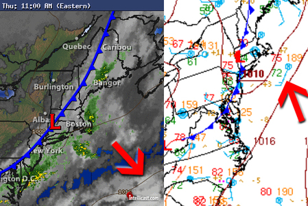
Now you may be asking, why did today's increasing chance in showers and thunderstorms suddenly drop to a mere 20% instead? Take a look at the surface observations below. The left (11am EST) is superimposed with the radar, and the right (1PM EST) is superimposed with the surface observations.
Now you may be asking, why did today's increasing chance in showers and thunderstorms suddenly drop to a mere 20% instead? Take a look at the surface observations below. The left (11am EST) is superimposed with the radar, and the right (1PM EST) is superimposed with the surface observations.
Two things to note here. The first is on the right image. The red arrow is pointing to the surface observations. The biggest thing to pay attention to is the direction and speed of the winds, which are coming in from the SW (winds point towards the center circle), and the long+short barbs at the end mean that winds are moving at 15 knots. Remember what I mentioned in the front lesson post, that winds move along the edge of a cold front, in this case from the SW. The biggest area of instability today has been due west and extending to the southwest, each slowly moving south as the cold front progressed. By the time that noon came around, those winds along the edge of the front pushed all of the heavy bands of rain offshore, missing us to the south. Eventually by 1PM all of the precip had eventually moved offshore to the south and east, and with the cold front directly over us, no convection stood a chance at making more showers.
So this brings us over to the left picture and the question, why did the chance of showers and storms drop so fast? Take a look at the what the red arrow on the left is pointing at. That's where the large area of high pressure was supposed to be until this afternoon, but instead the upper-level winds pushed it far out into the Atlantic, meaning that the cold front was free to push on through faster.
So there you have it. Keep your umbrellas on hand just in case until the weekend, especially into Sunday Monday and Tuesday as the sunshine will be in full force.
As for now, time to get a slurpee to counteract all this humidity.
-Mike Merin


 RSS Feed
