Last night at 11PM EDT, Bertha officially became our second named storm of the Atlantic season, reaching 45 MPH with 60 MPH gusts. The Tropical Storm is currently the same strength and moving NW at a moderate pace, but the good thing about the storm is two-fold: it will not hit the US mainland, and it will not increase above a tropical storm.
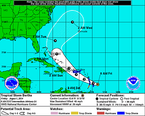
As far as its path, it will pass directly through the Lesser Antilles, through Puerto Rico and the Dominican Republic, just catch the eastern end of the Bahamas, and the turn east into the Atlantic on Tuesday morning.
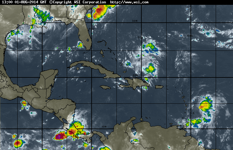
As you can see in the bottom right, the storm is still unorganized, the culprit being strong headwinds that are shearing the system apart. These winds will continue over the next 48 hours which will prevent Bertha from getting anywhere above 50 MPH. Below are the 24h and 48h winds.


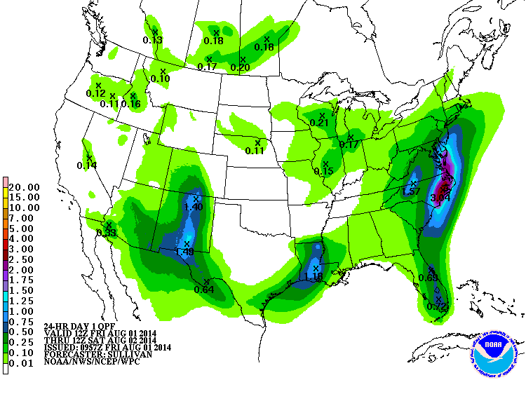
Back to the US though, you can see below where the storms are headed today. There are three major areas to look at:
A low pressure system is sitting between New Mexico and Arizona causing moderate precip, but high pressure in the center of the nation is stalling not just the low but the front as well, which will end up bringing almost an inch and a half of rain to much of the state, ironically more in the deserts in the south portion of the state.
The second area is in Louisiana where yet another area of low pressure is constantly drawing up moisture from the Gulf and dumping over an inch of rain to most of the state.
Finally the big weather-maker in the US, a very large low over Florida, along with not only a stationary front extending into the Atlantic but crosswinds coming from the Great Lakes will create a deluge in the mid-Atlantic seaboard today. West-central VA and NC will get what NM is getting today, at least an inch and a half, but western SC into the Delmarva Peninsula will see over 2", with the biggest rainfall in eastern NC seeing upwards of 3", most of it falling in the morning.
It's not all bad news though, a take at the good weather around the country:
Like yesterday almost the entirety of the center of the US from mid-Texas into ND will see sunshine today with no precip, as always California will be basking in sunshine, and even places like Washington state which usually have no shortage of passing showers will be in the clear.
Next up the high pressure over Nevada will keep any clouds away, though with 104° temperatures today I'd at least want some clouds to hind behind.
Finally ending in the NY Metro area, even though there's a slight chance of showers and thunderstorms in the mid-afternoon, the day will actually start off partly sunny before the clouds start to roll in closer to noon. Going farther north into New England they'll get a decent well-deserved break for the daytime after getting scattered showers and thunderstorms all last night.
Skipping past the weekend I'll just leave with this long-range news: Tuesday will be the start of a sunny trend, so look forward to that.
-Mike Merin

 RSS Feed
