Who wants to shovel more snow? Not me, so thank the warmer air from the south for the above freezing temps tonight. It'll seem like Mr. Fahrenheit will mistake AM for PM as tonight's temperatures will be rising throughout the night and tomorrow's temps will be falling throughout the day. Again that's good for us because the map below shows what we're in for tonight into Monday.
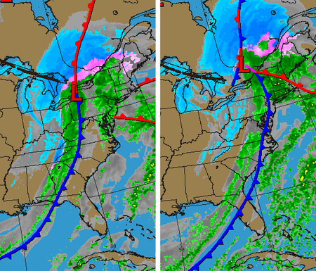
With temps rising into the upper 40's Monday night, along with the .4-.6" of rain we'll get the snow will start to melt considerably. But there's a downside: by 2PM we'll have a chance of flurries before it tapers off. Now this may not be bad, but when the temps drop below freezing we'll see a good chance of widespread ice on the roads as the liquid on the ground refreezes.
Make sure you have plenty of salt on hand to deal with it right away, as temps won't go back above freezing until Thursday afternoon, and then we'll see another round of snow showers towards Friday morning and during the day. We'll keep an eye on that though as temps will be hovering around the freezing mark with a slight chance of it being warmer (which makes all the difference).
Make sure you have plenty of salt on hand to deal with it right away, as temps won't go back above freezing until Thursday afternoon, and then we'll see another round of snow showers towards Friday morning and during the day. We'll keep an eye on that though as temps will be hovering around the freezing mark with a slight chance of it being warmer (which makes all the difference).
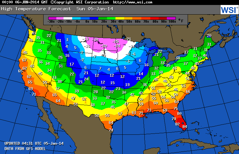
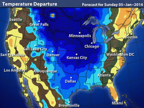
Elsewhere in the nation, the Eastern and Western edges are seeing above average temperatures but the center of the nation will be feeling the Wintery cold ESPECIALLY in the north where highs, yes highs will be in the negative teens and 20's, with lows at 30-40 below. Wind chills? Try 50-80 below as parts of North Dakota can see gusts of up to 30 MPH.
I leave you with a timeline of events for the NY Metro area:
Temps fall under freezingSunday: CHANCE OF LIGHT RAIN PASSING THROUGH, MUCH WARMER
3PM - 38° Light Rain
Sunday Night: CHANCE OF RAIN INCREASES, HEAVIER TOWARDS THE MORNING, STEADY TEMPS OVERNIGHT
10PM - 46° Light Rain
Monday: RAIN, TEMPS LOWER THROUGHOUT THE DAY, CONVERTS TO SNOW AROUND 3PM
3AM - 49° Rain
10AM - 42° Rain
2PM - 32° Chance of converting to snow. Temps fall under freezing
5PM - 30° Leftover flurries taper off. ICE ON ROADS AS LIQUID THERE FREEZES
8PM - 25° Winds pick up, liquid on ground starts to freeze if not salted
lows: 5-10°
-Mike Merin

 RSS Feed
