LABEL THE AIR MASSES WHATEVER...END RESULT....15 TO 30 DEGREES BELOW THE AVERAGE AGAIN NEXT WEEK. THERE ARE SIGNS OF MODERATION BY LATE NEXT WEEK...UNTIL THEN...FRIGID.
BELOW...SATELLITE PICTURESHOWS NEXT FRONT DIVING DOWN
FROM CANADA. THIS FRONT WILL BRING NEAR BLIZZARD CONDITIONS FROM NORTHERN PLAINS TO GREAT LAKES TODAY AND TONIGHT WITH SEVERAL INCHES OF SNOW AND WINDS TO 50 MPH AT TIMES.
BELOW...SATELLITE PICTURESHOWS NEXT FRONT DIVING DOWN
FROM CANADA. THIS FRONT WILL BRING NEAR BLIZZARD CONDITIONS FROM NORTHERN PLAINS TO GREAT LAKES TODAY AND TONIGHT WITH SEVERAL INCHES OF SNOW AND WINDS TO 50 MPH AT TIMES.

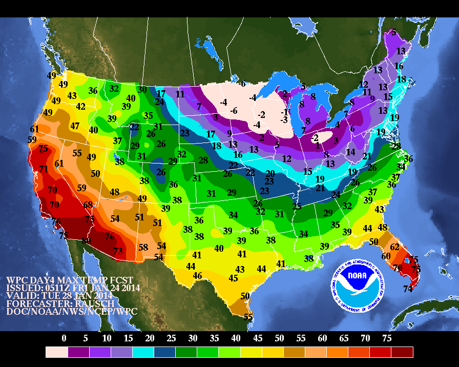
BELOW- MAP SHOWING TEMPERATURES FOR THIS COMING TUESDAY.
NORTHEAST WILL SEE 1"-3" OF SNOW SATURDAY INTO SATURDAY NIGHT...THEN LAKE EFFECT WILL TAKE OVER INTO EARLY NEXT WEEK. CLIPPER GOING THROUGH GREAT LAKES SHOULD NOT FORM INTO A MAJOR EAST COAST STORM. STILL SOME THOUGHT ABOUT A SECOND COASTAL STORM OFF THE SOUTHEAST TUESDAY/ WEDNESDAY...BUT RIGHT NOW WILL OPT TO SAY THAT IT MAY AFFECT THE SOUTHEAST BUT NO WHERE ELSE. NO DEFINED CALL ON SUPERBOWL SUNDAY BUT IF MODELS ARE ONTO A TREND..IT WOULD FAVOR MORE RAIN THAN SNOW.....WE'LL SEE. HAVE A NICE WEEKEND...KEEP WARM AND SAFE.
NORTHEAST WILL SEE 1"-3" OF SNOW SATURDAY INTO SATURDAY NIGHT...THEN LAKE EFFECT WILL TAKE OVER INTO EARLY NEXT WEEK. CLIPPER GOING THROUGH GREAT LAKES SHOULD NOT FORM INTO A MAJOR EAST COAST STORM. STILL SOME THOUGHT ABOUT A SECOND COASTAL STORM OFF THE SOUTHEAST TUESDAY/ WEDNESDAY...BUT RIGHT NOW WILL OPT TO SAY THAT IT MAY AFFECT THE SOUTHEAST BUT NO WHERE ELSE. NO DEFINED CALL ON SUPERBOWL SUNDAY BUT IF MODELS ARE ONTO A TREND..IT WOULD FAVOR MORE RAIN THAN SNOW.....WE'LL SEE. HAVE A NICE WEEKEND...KEEP WARM AND SAFE.

 RSS Feed
