With the elongation of the front to the northwest along with the Bermuda High stretching into the deep south, today's storms will be more isolated and less likely for NYC and Long Island, though anywhere north of the LI sound will still face a good chance of passing showers and thunderstorms starting around 2PM and intensifying around 5PM. 8PM seems like it will be the most likely time for precip to reach NYC and then Long Island, although with how erratic the storms will be, and nothing actually on the radar as of yet it's tough to tell the exact time they'll be coming through late in the day.
The good thing though is once the fronts move through tonight, temperatures will drop on the average of 7°, even more inland. While that may not seem like much, mid-upper 80's is a whole lot better than mid 90's, especially when you factor in the humidity.
The models seem to agree that around midnight the storms will temporarily subside before picking up once again early-midday tomorrow and intensifying around 2PM, repeating a similar cycle on Tuesday.
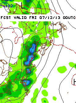
| Wednesday and Thursday both look like they'll be filled with scattered showers/storms throughout the day, with Thursday evening (pictured left) into the night being the greatest chance for severe thunderstorms and heavy rain passing through. Unfortunately the scattered pattern of showers and thunderstorms will continue for at least another week as the Bermuda High moves north, creating an easterly flow of winds and blocking the systems that are moving across the country towards us, keeping their energy and moisture right above us. |
It'll be wet and stormy but less hot and hazy, so be prepared to carry an umbrella around this week for the precip rather than the heat.
-MM
-MM

 RSS Feed
