The latest models just finished their runs, and the outlook just keeps on getting worse. At the moment the totals are:
NYC: 2.50-3" (~2.75") liquid precip, or 27-33" (~31)
LI/NJ, Western CT: 2.45-2.80" (~2.60") liquid precip, or 24-30" (~28)
Please note as well that on Tuesday from midnight until noon there is a chance of thundersnow occurring, and if hit those areas could see an extra 1-2" per hour for the duration of the thunderstorm, so locally the values could be much higher.
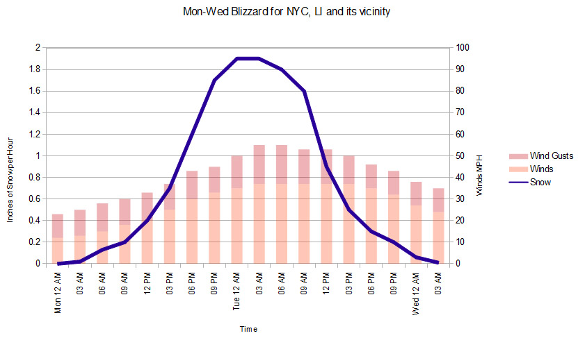
The 6 hour breakdown is as such for NYC (Long Island in parenthesis if different). I'll include winds as well this time as there will be blizzard conditions due to it.
Monday 3AM-6AM
Winds: NE 10-15 MPH
Precip: 10-20% snow showers
Snow: <.25”
Monday 6AM-12PM
Winds: NE 15-20 MPH
Precip: 80% snow showers
Snow: 1-1.5" (.50-.1")
Monday 12PM-6PM
Winds: NE 20-25 MPH G35
Precip: 100% snow
Snow: 2-3”
Monday Night 6PM-12AM
Winds: NE 20-35 MPH G40-50
Precip: 100% heavy snow
Snow: 5-8"
Monday Night 12AM-6AM
Winds: North 30-40 MPH G50-55 (North 35-45 MPH G50-60)
Precip: 100% very heavy snow with possible thundersnow
Snow: 9-12"
Tuesday 6AM-12PM
Winds: North 30-40 MPH G50-55 (North 35-40 MPH G50-60)
Precip: 100% very heavy snow with possible thundersnow
Snow: 7-10" (6-9")
Tuesday 12PM-6PM
Winds: NW 30-40 MPH G50 (North 35-40 MPH G50-60)
Precip: 100% snow
Snow: 2-4"
Tuesday Night 6PM-12AM
Winds: NW 30-35 MPH G40-45 (NW 30-40 G45-50)
Precip: 80% snow showers then 50% snow showers
Snow: 1-1.5”
Tuesday Night: 12AM-5AM
Winds: NW 20-25 MPH G35
Precip: 20-30% light snow showers
Snow: <.50"
In the time that it took for me to type all this out, I refreshed the models and they're the same. With the worsening trend lately I guess that's a good thing.
-Mike Merin
NYC: 2.50-3" (~2.75") liquid precip, or 27-33" (~31)
LI/NJ, Western CT: 2.45-2.80" (~2.60") liquid precip, or 24-30" (~28)
Please note as well that on Tuesday from midnight until noon there is a chance of thundersnow occurring, and if hit those areas could see an extra 1-2" per hour for the duration of the thunderstorm, so locally the values could be much higher.
The 6 hour breakdown is as such for NYC (Long Island in parenthesis if different). I'll include winds as well this time as there will be blizzard conditions due to it.
Monday 3AM-6AM
Winds: NE 10-15 MPH
Precip: 10-20% snow showers
Snow: <.25”
Monday 6AM-12PM
Winds: NE 15-20 MPH
Precip: 80% snow showers
Snow: 1-1.5" (.50-.1")
Monday 12PM-6PM
Winds: NE 20-25 MPH G35
Precip: 100% snow
Snow: 2-3”
Monday Night 6PM-12AM
Winds: NE 20-35 MPH G40-50
Precip: 100% heavy snow
Snow: 5-8"
Monday Night 12AM-6AM
Winds: North 30-40 MPH G50-55 (North 35-45 MPH G50-60)
Precip: 100% very heavy snow with possible thundersnow
Snow: 9-12"
Tuesday 6AM-12PM
Winds: North 30-40 MPH G50-55 (North 35-40 MPH G50-60)
Precip: 100% very heavy snow with possible thundersnow
Snow: 7-10" (6-9")
Tuesday 12PM-6PM
Winds: NW 30-40 MPH G50 (North 35-40 MPH G50-60)
Precip: 100% snow
Snow: 2-4"
Tuesday Night 6PM-12AM
Winds: NW 30-35 MPH G40-45 (NW 30-40 G45-50)
Precip: 80% snow showers then 50% snow showers
Snow: 1-1.5”
Tuesday Night: 12AM-5AM
Winds: NW 20-25 MPH G35
Precip: 20-30% light snow showers
Snow: <.50"
In the time that it took for me to type all this out, I refreshed the models and they're the same. With the worsening trend lately I guess that's a good thing.
-Mike Merin

 RSS Feed
