Today's rain may as well be a headache, though tomorrow's will be more for the amount rather than the difficulty in trying to forecast for it. Take a look at the current radar below:
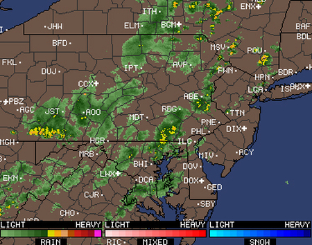
Summary: it's a complete mess. All of those bands are moving at slightly different speeds at slightly different angles, all ranging from intensifying to even dissipating completely. I cannot stress how difficult it is to try and forecast how these storms will move and the timing for them. But it's our job so here it goes:
For NYC and the Metro Area: Some small isolated rain cells are nearby, with rain cells, continuing until the heavier band of rain another 2 hours away (2PM, 40% chance of dissipating), while the heaviest and long-lasing showers and storms currently 3-4 hours away (3-4PM, 20% chance of dissipating or delaying).
Nassau County: Some small isolated rain cells are to the west, with rain cells, continuing until the heavier band of rain another 3 hours away (3PM, 50% chance of dissipating), while the heaviest and long-lasing showers and storms currently 4-5 hours away (4-5PM, 30% chance of dissipating or delaying).
Suffolk County: Some small isolated rain cells are to the west, with rain cells, continuing until the heavier band of rain another 4 hours away (4PM, 70% chance of dissipating), while the heaviest and long-lasing showers and storms currently 5-6 hours away (5-6PM, 30% chance of dissipating or delaying).
And this is only a few hours into the forecasting, see why tomorrow's a headache? Anyways, tomorrow's weather seems to be following a similar pattern to today's with more constant showers/storms slated to start hitting the metro area around noon. Friday is a much better day, partly sunny for the day with only a few showers/storms passing through, nothing too constant.
Finally the weekend: beautiful weather with plenty of sunshine and most importantly: much less humidity. You can go outside and not sweat just by waving to your neighbors.
Also for those wondering, Tropical Storm Chantal has high winds of 45mph with only 1011mb, moving pretty quickly at 30MPH to the WNW. It's currently south of the Dominican Republic, moving into range of Florida by Friday and will start dissipating over Florida by Saturday morning, so nothing for the Northeast to worry about.
-Mike Merin

 RSS Feed
