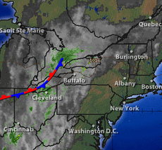
With temperatures reaching at or above 90° today and tomorrow for the Northeast, many of us will prefer to stay inside with our ACs and enjoy the holiday weekend. Combined with the fact that there are no clouds to block the blazing sun (current surface analysis is shown to the left), heat index values will be close to 100° or even higher locally inland. It's a bit windy today which will help cool us down a bit, but tomorrow is slated to be a degree or two hotter with almost no winds in sight, so take care if you have to go outside and make sure you're prepared.
Why so hot though? Well there's two major things affecting the airflow leading into the Eastern seaboard. Below is the Jet Stream:
Why so hot though? Well there's two major things affecting the airflow leading into the Eastern seaboard. Below is the Jet Stream:
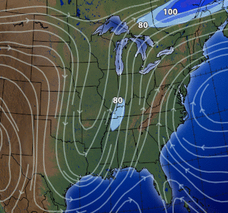
The Jet drops down in the mid-west and curls back up along the Eastern seaboard, carrying the very hot and humid air from the Gulf with it. On the right side of the screen is the reason why there's this severe curl, a Bermuda High that's blocking the air from continuing East while also drawing up heat from the Caribbean and simultaneously bringing higher pressure to the area. The two of these are funneling plenty of heat into the Northeast, with the Bermuda High cancelling out much of the precip from the Gulf, leaving us with an absence of cloud cover and an abundance of sweltering heat.
By Sunday however, the Jet will begin to take over the High, and the frontal system along the Eastern edge of the Jet will begin to move East once again, bringing a chance of showers and thunderstorms while also cooling temperatures down 5-10° as the front finally gathers the strength to push into the Atlantic once again. Remember that the rain many of us received in the beginning of the week (and some of NY state, VT, Eastern MA, and the areas west as well are still receiving today) is from this same system and front, and it'll be the same system and front bringing us a chance of rain Sunday into Tuesday. This blockage is what we say last year as well, though it blocked a large area of high pressure rather than precipitation.
So take care when you're outside, keep the AC on for your pets if you keep them in the car (at 90° even with the windows cracked temperatures inside the car can reach 100° just 10 minutes, 120° in a half hour), bring water with you, and keep cool until Sunday when the temperatures drop a few degrees and we have clouds to help us out.
-MM

 RSS Feed
