There are five parts of the Pacific and Atlantic to look at, with one of them being the soon-to-form Bertha. We'll get to that, but below is how the Eastern Pacific and the Atlantic currently looks.
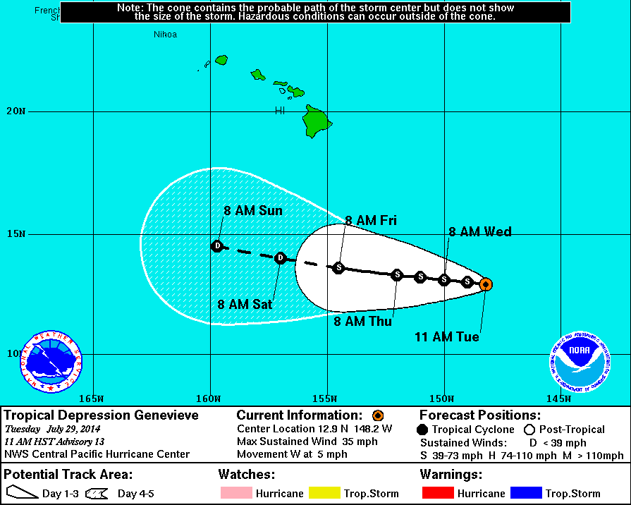
The only other storm not seen here is Genevieve which is further to the west, only a little southwest of Hawaii.
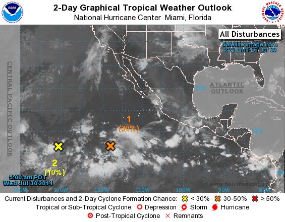
The second system to mention is the yellow X, a disorganized cluster of showers around 1500 miles off the Baja Peninsula, but is under a 20% chance of forming into anything and will most likely dissipate.
The third, not labeled on the pictures, is what was Hurricane Hernan, and what was classified as a post-tropical cyclone, meaning that it has less than Tropical Storm winds of at least 35 knots or 40 mph, now almost completely dissipated but still causing some storm surge along the Baja Peninsula as well as southern California.
The fourth is the orange X and is what was mentioned yesterday, at the time was a disorganized cluster of clouds and showers a few hundred miles wide to the SW of southern mexico. Now it's slightly more organized and the chance of it forming into a cyclone has increased quite a bit. It now has a 30% chance of forming into a cyclone over the next 48 hours, with an 80% chance over the next 5 days. It still looks to move NW and well away from any land.
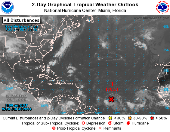
Now the Atlantic, that's where everyone's eyes are focused. The red X is 1100 miles east of the Virgin Islands, or over half the Atlantic Ocean away from the mainland of Africa. It's a very large system that has a 70% chance of forming into a Tropical depression over the nest 6 hours. Almost two months into the official Atlantic hurricane season this will be the second named storm this year behind Arthur, given the anme Bertha. Let's hope it doesn't form into something as destructive as the category 3 1996 storm of the same name and will instead be like 6 years ago when a category 3 Bertha barely came close to land at all.
It looks as if it will head into the Lesser Antilles, but a defined path past 5 days isn't clear as of yet. We'll check back in with that possibly Friday but more likely next week when we'll see if has any impact in the US.
-Mike Merin
The third, not labeled on the pictures, is what was Hurricane Hernan, and what was classified as a post-tropical cyclone, meaning that it has less than Tropical Storm winds of at least 35 knots or 40 mph, now almost completely dissipated but still causing some storm surge along the Baja Peninsula as well as southern California.
The fourth is the orange X and is what was mentioned yesterday, at the time was a disorganized cluster of clouds and showers a few hundred miles wide to the SW of southern mexico. Now it's slightly more organized and the chance of it forming into a cyclone has increased quite a bit. It now has a 30% chance of forming into a cyclone over the next 48 hours, with an 80% chance over the next 5 days. It still looks to move NW and well away from any land.
Now the Atlantic, that's where everyone's eyes are focused. The red X is 1100 miles east of the Virgin Islands, or over half the Atlantic Ocean away from the mainland of Africa. It's a very large system that has a 70% chance of forming into a Tropical depression over the nest 6 hours. Almost two months into the official Atlantic hurricane season this will be the second named storm this year behind Arthur, given the anme Bertha. Let's hope it doesn't form into something as destructive as the category 3 1996 storm of the same name and will instead be like 6 years ago when a category 3 Bertha barely came close to land at all.
It looks as if it will head into the Lesser Antilles, but a defined path past 5 days isn't clear as of yet. We'll check back in with that possibly Friday but more likely next week when we'll see if has any impact in the US.
-Mike Merin

 RSS Feed
