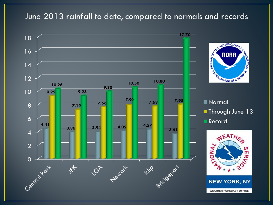
June has been a rather up & down month. Even the up times haven't been to enjoyable with humid conditions being the side-story to our sunny days. When it's been down, it's not just down, but downpour after downpour. Without seeing the rainfall records for June, it doesn't take a meteorologist to know that with the remnants of Andrea flooding the region on Friday the 7th in addition to our rain event this past Thursday the 13th, we are having a rather unusual we month. The normals for the month at all of the airports in the NY Metropolitan area have been shattered but we still have yet to break records for the month as the table below shows.
Speaking of looking to the past, we have had nice stretch of dry Father's Days. The last Father's Day with rain was in 2010 for the New York Metropolitan Area, and it didn't occur until in the late afternoon... Much like our scenario is looking for this Father's Day... As Mike so aptly mentioned, tomorrow morning the region will be waking up to sunshine but the clouds will start to roll in as the day progresses and current models are trending towards rain shower activity spreading into the northeast region in the afternoon hours... A good portion of tomorrow late may be a case of making sure you're staying alert and keeping a keen eye on a radar as some cases of showers & thunderstorms pass through the region. Temperatures tomorrow will be very similar to today's temperatures you felt, but with a bit more humidity to the air.
After Sunday's front moves off to into the ocean, a Low will pass to the north & its weak cold front will approach and pass through the northeast Monday into early Tuesday. General expectations are that Monday will have plenty of sun, but if you see clouds coming towards you, there are likely rain or thunderstorms moving in as well. The last concern at the moment is Tuesday into with an area of low pressure passing mostly to the south of the Northeast region, but bring some more rain to the Mid-Atlantic States. We will continue to monitor the development of this system and gain more understanding of its track in the next 24 hours. Once we clear that hurdle, the sun will shine bright with high pressure settling in and it will not budge for quite some time.
Take care & be well. Enjoy Father's Day!
- JL
Take care & be well. Enjoy Father's Day!
- JL

 RSS Feed
